Backpack: Hailey Pass - Lizard Head - Cirque of the Towers L 
Distance: 40.3 miles (loop)
Bridger and Popo Agie Wildernesses, Bridger-Teton and ShoshonesNational Forests, near Big Sandy in Wyoming's Wind River Range
Cirque of the Towers from Jackass Pass
This great loop trip in the southern Wind River Range climbs over Hailey and Jackass Passes, crosses the spectacular Lizard Head Plateau and visits the amazing Cirque of the Towers.
- Distance: 40.3 miles
- Elevation: 11,160-ft. at Hailey Pass
9,964-ft. at Graves Lake
9,980-ft. at Bear Ears Trail Junction
11,864-ft. at High Point on the Lizard Head Plateau
10,166-ft. Lonesome Lake/Cirque of the Towers
10,790-ft at Jackass Pass
9,085-ft. at Big Sandy Trailhead - Difficulty: strenuous
- More Hikes in:
Big Sandy / Wyoming's Wind River Range
Introduction
From the Big Sandy trailhead follow the Fremont Trail as it heads north, paralleling the west side of the Continental Divide. Along the way the trail passes four beautiful lakes and offers fine views of the massive cirque at the head of the East Fork Valley.
Beyond Marms Lake follow the Pyramid Lake trail, which crosses Washakie Creek and then turns right (east) on the Hailey Pass Trail, after passing Skull Lake. The climb to the pass (11,160-ft.) travels beneath Pyramid Peak and pass the pretty Twin Lakes. Atop the pass, views open east to the Musembeah massif (12,593-ft.) along with Redwall Peak, Buttress Mountain and Grave Peak (12,255-ft.) rising above emerald green meadows of the Baptiste and Grave Creek Valleys. Mt Hooker’s distinctive profile towers above the pass to the northwest.
From the pass a very steep descent through talus and meadows leads to a crossing of Baptiste Creek where the trail turns east. Soon the trail follows an undulating course high above Grave Lake before dropping to the lake’s northern shore. Here the trail traverses the north and then eastern shores to the foot of the lake.
Beyond the lake the path crosses a ridge separating the Graves and South Fork Little Wind River valleys and then drops to a trail junction on the western shore of the South Fork Little Wind River. At the junction the path turns right (east) on the Bear Ears trail, crosses the river and then climbs on moderate grades to the Lizard Head Plateau, passing Valentine and Little Valentine Lakes along the way.
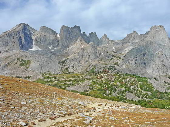
Atop the plateau turn right (south/southeast) on the Lizard Head trail. Jaw-dropping views of an incredible panorama of high peaks in the southern Wind River Range slowly evolves as you traverse the tundra-clad plateau to a high point at 11,864-ft.
From the high point the trail drops on moderate and then very steep grades to Lizard Head Meadows. The path now turns west on the North Fork Trail, traveling through forest and meadows to Lonesome Lake (10,166-ft.). Here the Cirque of the Towers, an amazing spectacle of jagged peaks and spires rising over 12,000-ft., soar above the beautiful lake.
The final leg of the backpack ascends steeply to Jackass Pass (10,790-ft.), accompanied by more great views of the cirque. From the pass the very strenuous path follows a roller coaster route through rocky terrain, climbing over rock slabs and detouring around boulders and rock outcroppings along the west sides of Arrowhead and North Lakes. To the south, views unfold to the high peaks towering above the Deep and Temple Lake drainages.
After three miles, the trail drops down switchbacks to Big Sandy Lake. From the lake the Big Sandy Trail descends on easy to moderate grades back to the Big Sandy Trailhead.
This great backpack requires a minimum of 3-nights/4-days. I recommend allocating five or more days for the trip. The extra time will enable a more leisurely pace and allow time for day hikes, fishing and other pursuits.
Backpack Segments
- Segment 1: Big Sandy Trailhead to Marms Lake
- Segment 2: Marms Lake to Hailey Pass Trail Junction
- Segment 3: Over Hailey Pass to Valentine Lake
- Segment 4: Valentine Lake to Cirque of the Towers Via Lizard Head
- Segment 5: Cirque of the Towers to Big Sandy Trailhead via Jackass Pass
Elevation Profile
Mileage and Elevation Detail
| Miles | Elevation | Destination | |
|---|---|---|---|
| 0.0 | 9,085-ft. | Big Sandy Trailhead | |
| 0.6 | 9,120-ft. | Junction Sedgewick Meadow (Big Sandy) (bear left) | |
| 1.3 | 9,320-ft. | Junction Diamond Lake (bear left) | |
| 1.5 | 9,355-ft. | Junction Fremont Trail (bear right) | |
| 5.5 | 9,741-ft. | Dad’s Lake | |
| 6.8 | 9,878-ft. | Marms Lake | |
| 7.4 | 9,925-ft. | Junction with Pyramid Lake Trail (bear right) | |
| 9.0 | 10,160-ft. | Junction Shadow Lake trail (continue straight ahead) | |
| 9.1 | 10,090-ft. | Washakie Creek Crossing | |
| 9.9 | 10,410-ft. | Junction with Washakie Pass Trail | |
| 10.2 | 10,282-ft. | Skull Lake | |
| 11.2 | 10,375-ft. | Junction Hailey Pass (turn right) | |
| 13.3 | 11,160-ft. | Hailey Pass | |
| 14.7 | 10,310-ft. | Junction Baptiste Lake Route | |
| 15.9 | 9,964-ft. | North shore of Graves Lake | |
| 17.2 | 9,975-ft. | Bridge over Graves Lake Outlet | |
| 18.7 | 9,895-ft. | Junction Moss Lake Trail (continue straight ahead) | |
| 19.9 | 9,980-ft. | Junction Bear Ears Trail (turn left and cross river) | |
| 21.0 | 10,399-ft. | Valentine Lake (camping) | |
| 16.7 | 10,399-ft. | Valentine Lake (camping) | |
| 23.7 | 11,525-ft. | Lizard Head Trail Junction (turn right) | |
| 26.6 | 11,864-ft. | High Point on the Lizard Head Trail | |
| 29.3 | 10,025-ft. | Junction North Fork Trail (turn right) | |
| 31.3 | 10,166-ft. | Lonesome Lake | |
| 32.1 | 10,790-ft. | Jackass Pass | |
| 34.8 | 9.690-ft. | Big Sandy Lake (camping) | |
| 40.3 | 9,085-ft. | Big Sandy Trailhead |
Trailhead Driving Directions
The Big Sandy Trailhead is located in the southern Wind River Range next to the Big Sandy River.
Directions from Pinedale: From the intersection of Pine Street (US 191) and North Tyler Ave (the Pinedale Tourism office is located on the northeast corner) in Pinedale, WY, drive south on Highway 191 for 11.7 miles and then turn left (east) on WY-353. After 15.5 miles you will notice signs referring to the road as the Big Sandy-Elkhorn Road and after 18 miles the paved road will change to a good packed dirt/gravel surface.
Shortly after the pavement ends go straight through a junction, and drive south crossing the Big Sandy River (Buckskin Crossing). Follow the road for a total of 27.3 miles. Shortly after crossing the Big Sandy River you will reach a junction with the Lander Cutoff Road (the next junction). Turn left on the Lander Cutoff Road. There is a wood sign at the intersection pointing toward the Big Sandy trailhead.
Drive 7.0 miles on the Lander Cutoff Road and then turn left on the Big Sandy Opening Road. Here you will see a sign for the Big Sandy Campground and trailhead. The road now deteriorates and narrows. Blind corners and lush foliage along the road make it hard to see ahead. Drive carefully, following the rocky, rutted road for 9.8 miles to a "Y" intersection. Bear right at the intersection to continue along the Big Sandy Opening Road (Forest Service Road 850). (The road branching to the left leads to the Big Sandy Lodge and Mud Lake.) Follow the road for 0.8 miles to the trailhead parking area, equipped with an outhouse.
Allow an hour and a half to reach the trailhead from Pinedale. The parking area is too small for the number of backpackers visiting the area during the height of the summer. If the parking area is full, find a safe place to park off the access road.
I recommend a high clearance vehicle to reach the trailhead. Passenger cars can make it OK if driven carefully. Check at the Pinedale ranger station before starting your trip to learn about current road and trail conditions. The Ranger Station is located to the east of the Ridleys Grocery Store on US 191 (Pine Street in Pinedale). The entrance to the ranger station is on the Fremont Lake Road. (You can also reach the parking area for the ranger station by driving east through the Ridley’s parking lot.)
This trailhead is remote, so be sure to have a full tank of gas. The dirt road become slippery when wet. The campground at the parking area is tiny, with only 4 sites. I would not plan on camping at the trailhead before starting your backpack.
Trail Resources
Trail Photo Gallery / Trail Map
Basecamp(s) Information:
Big Sandy
Region Information:
Wyoming's Wind River Range
Other Hiking Regions in:
Wyoming