Holmes Cave 
Distance: 5.6 - 9.5 miles
Teton Wilderness Area, Teton National Forest, near Togwotee Pass in The Tetons
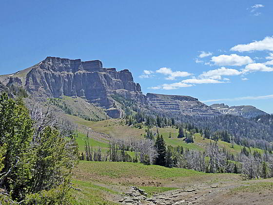
The Breccia Cliffs
Solitude, lovely meadows and great views of the volcanic formation around the Togwotee Pass area are the highlights of this hike through in the southern Absaroka Mountains, located to the northeast of the Tetons.
- Distance: 5.6 - 9.5 miles (RT)
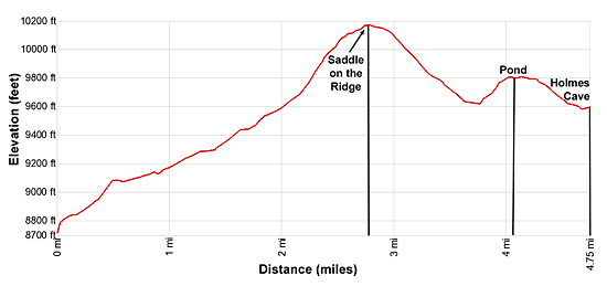
- Elevation: 8,710-ft. at Trailhead
Maximum elevation - 10,170-ft. - Elevation Gain: 1,460-ft.
- Difficulty: moderate
- Basecamp: Togwotee Pass / Jackson
- Region: The Tetons
Trail Description - Holmes Cave
It’s the journey and not the destination that makes this hike worthwhile. This trail travels through beautiful country in the southern Absaroka Range with fine views of the North Breccia Cliffs. At the height of the summer the meadows along the trail are filled with wildflowers. Distance views encompass the summits of the Tetons, the Wind River Range and the peaks in the Gros Ventre along with Terrace Mountain, Thorofare Mountain and Younts Peak in the Teton Wilderness.
This hike is a great option for anyone looking for some solitude and an off-the-beaten path destination. Shorten the hike to 5.6 miles (round trip) by turning around at the saddle on the ridge between Angle Mountain and the North Breccia Cliffs. The saddle and the area just beyond the saddle offer fine views of the high peaks in the Teton Wilderness and the North Breccia Cliffs in addition to distant views of the Gros Ventre and Wind River Ranges.
Note: This hike situated in the southern Absaroka Range near Togwotee Pass, located to the northeast of Grand Teton National Park. The hike is also easily accessible from Dubois, Wyoming. There is some up and down on this hike so the elevation gain to Holmes Cave is actually 1,667-ft. and the loss is -818-ft.
The trail to Holmes Cave starts at the northwest end of the trailhead parking lot. (See trailhead directions below.) Follow the trail as it ascends north up a dirt road on moderate grades, passing the old wood Ranger Rider Cabin at 0.2 miles. Beyond the cabin the road narrows to a trail and passes a sign for Holmes Cave.
Past the sign the path climbs along the eastern edge of a pretty meadow scattered with willows and small copses of trees, crossing a creek along the way. Sections of this trail can be muddy early in the season.
After walking 0.5 miles the path curves to the right (northeast) and enters a drainage to the west of the North Breccia Cliffs. The path now ascends on easy to moderate grades through pretty meadows sprinkled with sage and awash with wildflowers during the height of the summer. Along the way the trail crosses a tributary creek at 0.75 miles and then the drainage’s main creek at 0.9 miles.
Past the creek crossings the path ascends along the northwest side of the drainage. Ahead views open to the North Breccia Cliffs. Behind you are views of the rolling hills to the south of the Togwotee Pass.
At 1.4 miles the grade steepens as the trail curves to the left, climbing north/northeast toward a saddle on the ridge between Angle Mountain to the west and North Breccia Cliffs to the east. As you gain elevation turnaround for views of the Tetons rising beyond the hills to the southwest.
As you climb enjoy ever improving views of the North Breccia Cliffs to the northeast. To the south (behind you) are distant views of the peaks in the Gros Ventre.
At 2.0 miles the path curves to the north, ascending along the west side of a creek. In a quarter mile the path starts curving to the left (northwest) as it zig-zagging up the hillside on steep to moderately-steep grades through meadows and small stands of whitebark pine and subalpine firs. As you near the saddle, great views open to the Breccia Cliffs and the Wind River Range, seen in the distance to the southeast. The peaks of the Gros Ventre rise above the rolling hills to the south.
At 2.6 miles pass a sign marking the boundary for the Teton Wilderness. As short distance beyond reach the high point of the hike (10,170-ft.), the saddle on the ridge between Angle Mountain and the North Breccia Cliffs, at 2.8 miles. To the north views open to Terrace Mountain rising above the South Fork of the Buffalo River and, in the distance, the cliffs rising above the North Fork of the Buffalo River Valley. The saddle is a good turn around point for parties looking for a shorter day.
Beyond the high point the trail curves to the northeast and descend on easy grades though meadows. Here views stretch northeast to Thorofare Mountain and Younts Peak. At 3.0 miles the trail curves to the right (east), descending on moderate to moderately-steep grades through beautiful meadows filled with wildflowers in mid to late-July. The narrow, boot-beaten path may fade a bit through the wet meadows, but soon reappears. Great views of the Breccia Cliffs accompany the descent that loses about 570-ft. in a mile from the saddle.
At 3.8 miles the trail crosses a small creek. Depending on the time of the year you may also need to hop over some small tributary streams trickling down the meadows. The path now heads northeast, climbing over a low hump. A short steep ascent through forest and small meadows leads to a pond nestled atop the hump. The trail levels as it skirts to south side of the pond and then descends down the east side of the hump on easy to moderate grades, passing a small tarn along the way.
At 4.5 miles the trail curves to the left (north). Soon the grade abates and the trees give way to meadows. At 4.6 miles, at the base of the hump, the trail crosses a stream and then descends gently as it curves around a meadow clad bowl, actually a large sink. The stream runs down the floor of the bowl to the left (west).
At 4.7 miles the trail and the stream converge below a limestone outcropping. The stream disappears down a hole in the rocks. This is the mouth of Holmes Cave. The cave was discovered by E. B. Holmes and a group of friends in 1898. The stream flows down a series of waterfalls within the cave, including a 9-ft. and 16-ft.falls. At the bottom of the falls a passage leads to a large room. A breakdown (collapse) hampers further exploration. No one has explored the entire length of the cavern.
The cave is dangerous, unstable and should not be entered. Hikers looking for an additional challenge might follow a faint trail that heads northeast from the cave and then crosses a low saddle. From the saddle descend east into a drainage and then plot a route to the top of Simpson Peak (9,910-ft.).
Otherwise, turnaround at the cave and enjoy the beautiful meadows and nice views on the return leg to the trailhead.
Elevation Profile
Driving Directions
From Dubois: From the corner of N 1st Street and US 26 in Dubois, drive 35.0 miles west/northwest on US 26/US 287 and turn right (north) into a signed dirt road (Forest Service #30042) for Holmes Cave. Drive 0.1 mile up the road to an obvious parking lot. The turn is 4.9 miles to the west of Togwotee Pass.
From Jackson: From the corner of W. Broadway and Cache Streets, at the southwest corner of the Jackson Town Square, head north on N Cache Street (US 191 N/US 89 N/ US 26 E) for 30.1 miles to Moran Junction. Here US 191/US 89 turn left toward the Jackson Lake area of Grand Teton National Park and Yellowstone. We bear right (east) on the continuation of US 26 E/ US 287 toward Dubois. Drive 20.4 miles east and turn left (north) into a signed dirt road (Forest Service #30042) for Holmes Cave. Drive 0.1 mile up the road to an obvious parking lot.
If you get to Togwotee Pass you have missed the turn. Turn around at the pass and drive 4.9 miles to the west to the turn, now on your right.
Trail Resources
- Trail Photo Gallery
- Trail Maps
- Basecamp(s) Information: Togwotee Pass / Jackson
- Region Information: The Tetons
- Other Hiking Regions in: Wyoming