Pinnacle Butte North and Pinnacle Butte West
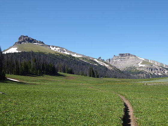
This short trail leads to the beautiful meadows of Bonneville Pass with nice views of Pinnacle Buttes and the volcanic peaks and cliffs rising above the Brooks Lake area and the Dunoir Valley, located to the northeast of the Tetons.
- Distance: 5.2 miles (RT)
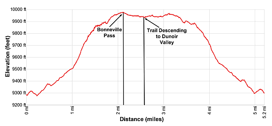
- Elevation: 9,285-ft. at Trailhead
Maximum elevation - 9,976-ft. - Elevation Gain: 691-ft.
- Difficulty: moderate
- Basecamp: Togwotee Pass / Jackson
- Region: The Tetons
Trail Description - Bonneville Pass
Enjoy some solitude on this scenic trail ascending the Bonneville Valley to the flower-filled meadows of Bonneville Pass. The path enjoys great views of southern end of Pinnacle Buttes soaring above Jules Bowl, Sublette Peak and the volcanic cliffs rising above the Continental Divide, Coffin Butte and the headwall towering above the Dunoir Valley.
Note: This hike, situated in the southern Absaroka Range near Togwotee Pass, is located to the northeast of Grand Teton National Park. The hike is also easily accessible from Dubois, Wyoming.
The Dunoir Trail to Bonneville Pass starts at the east side of the trailhead parking area, located to the northeast of Brooks Lake. (See driving directions below.) Signs at the trailhead list the distance to Bonneville Pass as 3 miles. The actual one-way mileage for the trail is 2.6 miles. In the past the hike to Bonneville Pass could be extended and turned into a loop hike that visited the Kisinger Lakes and then followed the Pinnacles trail back to the trailhead. Unfortunately the Pinnacles Trail is now closed due to a landslide.
From the trailhead, walk east/northeast on the Dunoir Trail through trees and small meadows along the south side of the Bonneville Valley. Views encompass the unnamed butte rimming the valley to the north (left). At 0.2 miles the path jumps over a tributary creek and then crosses Bonneville Creek to the north side of the Bonneville Valley. Beyond the crossing the path ascends on easy to moderate grades through forests and intermittent meadows up the north side of the valley.
At 0.9 miles the trail passes through a large meadow where views open right (south) to Jules Bowl at the head a side valley. A scenic cirque of 11,000-ft. volcanic cliffs, situated along the north side of Pinnacle Butte, form an arc around the bowl. Pinnacle Butte West (11,175-ft.) and North (11,245-ft.) bookend the cirque to the west and east, respectively. At the head of the cirque is a highly eroded flat-top wall defining the north face of Pinnacle Butte HP (11,516-ft). To the west are nice views of Sublette Peak and the volcanic cliffs rising above the Continental Divide.
Soon the ascent steepens as the path continues climbing along the north side of the valley, crossing a few side streams along the way. 1t 1.5 miles the grade eases and the trees give way to beautiful meadows, filled with wildflowers during the height of the summer.
At 1.75 miles the trail curves to the east, crosses the nascent Bonneville Creek to the south side of the valley and then turns east/northeast, resuming its ascent on easy to moderate grades toward the pass.
Reach the high point of the hike at 2.0 miles and a sign marking the boundary for the Dunoir Special Management Area. Beyond this point bikes, ATVs and snowmobiles are prohibited to protect the fragile meadows. Here views open northeast to the rugged volcanic cliffs rimming the head of the Dunoir Valley. Turn around for more great views of Pinnacle Butte West, Sublette Peak and the cliffs rising to the west.
According to USGS topo maps the actual pass is somewhere round this point. I recommend continuing on the trail that now descends gently through lovely meadows. Soon views open to a pretty tarn nestled in meadows along the valley floor, set against a backdrop of the volcanic cliffs to the northeast.
Beyond the tarn views of the cliffs at the head of the Dunoir Valley continue to evolve and improve with every step. Be sure to turn around for great views of Pinnacle Butte North and Pinnacle Butte West to the southwest.
At 2.5 miles the trail crosses Dunoir Creek, emanating from the tarn. At 2.6 miles the trail starts a steep drop into the Dunoir Valley. I recommend staying on the south side of the creek and walk off-trail northeast, traveling through some trees to the edge of the ridge above the east side of the Dunoir Valley. Across the valley Coffin Butte soars above the Dundee Meadows. The valley’s rugged headwall dominates the view to the northeast.
When you are done taking in the views retrace your steps to the trailhead. Please keep in mind that you are traveling through Grizzly Bear habitat. On my last trip to the pass we enjoy watching a bear grazing in the meadows high above the north side of the valley. Make plenty of noise and don’t travel alone through this area.
Elevation Profile
Driving Directions
From Dubois: From the corner of N 1st Street and US 26 in Dubois, drive 29.6 miles west/northwest on US 26/US 287 to the signed turnoff for the Brooks Lake Recreation area on the right (north) side of the road. Turn right (north) and follow the Brooks Lake Road, a good dirt road, for 5.6 miles. Along the way you will pass turns for the Brooks Lake Lodge, Brooks Lake Campground and the Pinnacles Campground. Take the next left after the Pinnacles Campground onto Forest Road #516. (There should be a sign here for Bonneville Pass.) Drive 1.7 miles to the Dunoir Trailhead to Bonneville Pass at the end of the road.
From Jackson: From the corner of W. Broadway and Cache Streets, at the southwest corner of the Jackson Town Square, head north on N Cache Street (US 191 N/US 89 N/ US 26 E) for 30.1 miles to Moran Junction. Here US 191/US 89 turn left toward the Jackson Lake area of Grand Teton National Park and Yellowstone. We bear right (east) on the continuation of US 26 E/ US 287 toward Dubois. Drive 25.8 miles east to the signed turnoff for the Brooks Lake Recreation area on the left (north) side of the road. (You will cross Togwotee Pass at 25.3 miles.)
Turn left (north) and follow the Brooks Lake Road, a good dirt road, for 5.6 miles. Along the way you will pass turns for the Brooks Lake Lodge, Brooks Lake Campground and the Pinnacles Campground. Take the next left after the Pinnacles Campground onto Forest Road #516. (There should be a sign here for Bonneville Pass.) Drive 1.7 miles to the Dunoir Trailhead to Bonneville Pass at the end of the road.
Trail Resources
- Trail Photo Gallery
- Trail Maps
- Basecamp(s) Information: Togwotee Pass / Jackson
- Region Information: The Tetons
- Other Hiking Regions in: Wyoming