Queens Garden / Navajo Loop 
Distance: 2.0 - 3.1 miles
Bryce Canyon National Park, near Bryce in South Central Utah
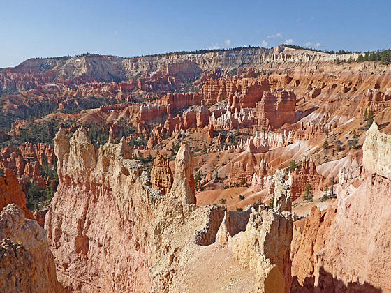
View of Queens Garden
Experience hiking through a maze of weird and wonderful rock formations in Bryce Canyon on the Queens Garden-Navajo Loop trail. The trail is the perfect option for hikers short on time or looking for an easier day.
- Distance: 2.0 - 3.1 miles (Loop)
- Elevation: 8,000-ft. at Trailhead
Maximum elevation - 7,425-ft. - Elevation Gain: -575-ft.
- Difficulty: moderate
- Basecamp: Bryce
- Region: South Central Utah
Trail Description - Queens Garden / Navajo Loop
Note: This trail loses and gains 575-ft. on the loop.
The Queens Garden / Navajo Loop trail is a great option for anyone short on time or looking for the easiest way to descend into the labyrinth of hoodoos, spires and fins in Bryce Canyon. The hike combines the Queens Garden, Navajo trail and a portion of the Rim trail to create a scenic loop.
Start the hike at either Sunrise or Sunset Point. This description begins at Sunrise Point, descends the Queens Garden trail to floor of Bryce Canyon, ascends out of the canyon via the Navajo Trail and then follows the Rim Trail back to Sunrise Point. (See driving directions below.)
From the parking lot/shuttle bus stop at Sunrise Point, walk east toward the rim. Turn right (south) when you reach the Rim Trail. The Rim Trail features fine views of the multi-hued hoodoos, spires, fins and ridges of Bryce Canyon. Boat Mesa, a long slender peninsula, juts into the canyon to the north while Bristlecone Point (7,796-ft.) rises to the northeast.
At 0.2 miles reach the junction with the Queen Garden trail, branching left (east). Ahead is Sunrise Point, a stunning overlook above the Queens Garden. Turn left and follow the Queens Garden Trail, a broad, hard packed trail descending on moderately-steep grades down the spine of a ridge. Along the way enjoy fine views of the colorful rock formation and ridges in the canyons below the trail and beneath the rim to the south.
After half a mile the trail drops down a series of switchback and then turns southeast, continuing the descent along the ridge to a junction with the horse trail, branching left (east), at 0.7 miles. We continue on the Queens Garden trail.
A short distance past the intersection the trail turns west and drops down switchbacks before crossing two low ridges. Along the way the path travels through tunnels chiseled through fins. Weird and wonderful rock formations jut from the ridges along the trail.
After passing through the third tunnel reach a junction at 0.9 miles with a spur trail branching right toward the Queen Victoria formation. The 0.1 mile (round-trip) detour takes you through a garden of fins, hoodoos and spires to the queen, located along a tall fin eroded into pinnacles. The pinnacle on the left side of the formation seems to be wearing a crown and gesturing toward the other formations in the garden. (Use your imagination to see the likeness.)
At this point you can either return to the trailhead for a 2.0 miles round-trip hike or continue down the Queens Garden trail toward the junction with the Navajo Trail.
To continue toward the Navajo trail, return to the junction and continue descending the Queens Garden Trail through scattered trees into Bryce Canyon. The trail heads generally south and then southwest. As you near the canyon bottom nice view open to formation along the rim around Inspiration Point to the southwest.
At 1.75 miles reach a four-way junction. To the left is the trail heading toward the Peek-a-boo Loop. Straight ahead (west) is the Wall Street leg of the Navajo Loop which is now closed due to a rock slide. (You can go 0.3 miles up the trail to see the slide.) We turn right (north) is the Navajo Trail ascending to the rim at Sunset Point.
The trail now climbs through interesting rock formations, gaining over 480-ft. in half a mile. At 2.0 miles the trail passes the short spur trail to Two Bridges, a double bridge, and then climbs a series of well-constructed switchbacks. The final leg of the ascent is along the north side of a ridge features fine views of Thors Hammer, the Three Gossips, Boat Mesa, and Bristlecone Point.
The grade abates at 2.3 miles as the trail reaches a junction with the Wall Street Trail. You can walk a short distance along the Wall Street Trail to the closure. Here steep switchbacks drop down a narrow corridor lined with massive fins.
When you are done looking into the abyss, a short climb leads to the rim and Sunset Point with stunning views of Silent City and the Bruce Canyon Amphitheater. After taking in the views, proceed north on the Rim Trail back to Sunrise Point at 2.9 miles. This scenic section of the Rim features terrific views of the Queens Garden amphitheater a well as Boat Mesa and Bristlecone Point. From Sunrise Point it is 0.2 miles back to the parking area/shuttle bus stop for a memorable 3.1 mile hike.
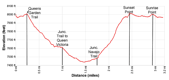
Elevation Profile
Driving Directions
From the Bryce Canyon Visitor Center to Sunrise Point: From the Visitor Center, located along UT 63, head south on UT 63 for 0.5 miles and then turn left onto the Sunrise Point access road. Follow the access road for 0.5 miles and turn left toward the Sunrise Point parking area. There are parking spots along the side of the access road and a small lot near the trailhead. More parking is located near the General Store. These parking lots fill early in the day during the height of the tourist season.
Alternatively, take the Park Shuttle Bus to the Sunrise Point stop (stop 8). The buses run every 10-15 minutes from April to October. The shuttle bus parking lot is located along UT 63, a short distance past Ruby’s Inn (in the hotel area). Limited parking is also available at the Bryce Visitor Center (stop 1), located 2.4 miles from the parking area.
From Bryce Canyon Visitor Center to Sunset Point: From the Visitor Center, located along UT 63, head south on UT 63 for 1.2 miles and then turn left onto the Sunset Point access road. Follow the access road for 0.3 miles to the end of the road and the parking area. A number of trail head east/southeast to the rim. The trail directly to Sunset Point is at the southeast end of the parking lot. Note: The parking lot fills early in the day during the height of the tourist season.
Alternatively, take the Park Shuttle Bus to the Sunset Point stop (stop 6). The buses run every 10-15 minutes from April to October. The shuttle bus parking lot is located along UT 63, a short distance past Ruby’s Inn (in the hotel area). Limited parking is also available at the Bryce Visitor Center (stop 1), located 2.4 miles from the parking area.
Trail Resources
- Trail Photo Gallery
- Trail Maps
- Basecamp(s) Information: Bryce
- Region Information: South Central Utah
- Other Hiking Regions in: Utah