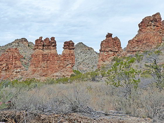
Fins eroded into pinnacles and hoodoos
This trail visits the Homer Wilson Ranch and then ascends Blue Creek Canyon for 1.75 miles to an area of colorful red rock formations. Continue up the canyon for fine views of Peaks 6720 and 7150 before the trail makes a steep ascent to Laguna Meadows on the Chisos Rim.
- Distance: 3.5 - 7.2 miles (RT)
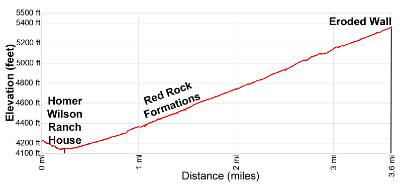
- Elevation: 4,160-ft. at Trailhead
Maximum elevation - 5,383-ft. - Elevation Gain: 1,223-ft.
- Difficulty: easy-moderate
- Basecamp: Big Bend
- Region: Texas Parks
Trail Description - Blue Creek Canyon

The parking area for the Blue Creek Canyon trailhead is located at a pullout along the east side of the Ross Maxwell Scenic Drive (see driving directions below). From the parking area the trail up Blue Creek Canyon quickly comes to a junction. To the left is a very short spur trail to an overlook with fine views of Carousel Mountain and the Homer Wilson Ranch to the southeast.
After taking in the views at the overlook return to the junction and follow the main trail (the right branch) as it drops on moderate grades to the broad floor of Blue Creek Canyon. After a quarter mile the path reaches a junction. Straight ahead (south) is the Dodson Trail. We turn left on the Blue Creek path, which soon crosses the wash and quickly reaches the Homer Wilson Ranch House, located on a bench along the south side of the wash.
The building was actually Wilson’s second ranch house, with the main headquarters for the ranch in Oak Canyon. The 24- by 60-ft structure, constructed of wood, stone, concrete and sheet metal, is in very good condition. A large porch on the south side of the building enjoys fine views of Carousel Mountain, towering above the house, and Goat Mountain, rising in the distance to the southwest.
After exploring the ranch house return to the main trail and start hiking up the wash (east) on gentle grades. Peak 6728, towering above the south side of the canyon, dominates the view to the east while colorful rock formations decorate the lower section of the canyon about one mile upstream.
The trail alternates between walking in the wash and the adjacent benches clad in desert grasslands. Rock cairns mark the way. After 0.6 miles the trail curves to the northeast and starts ascending on easy to moderately-easy grades. Ahead are more views of the red rock formations.
At 1.0 mile reach the red rock formations. Be sure to turn around just before the canyon makes a jog to the right (southeast) for distance views stretching southeast to the high cliffs rising above the Rio Grande. With a zoom lens you should be able to pick out the mouth of Santa Elena Canyon.
As the canyon curves to the right (southeast) we enter a wonderland of red rock pinnacles, towers and balanced rocks set amid the grassy terrain. Soon the canyon constricts and the trail is forced back into the wash now rimmed by rugged red rock walls. This section is short and the canyon soon widens. Here fins extending from the canyon walls are eroded into pinnacles and hoodoos. Small buttes sculpted by wind and water into fanciful shapes rise above the wash. Balanced rocks sit atop some of the formations.
At 1.3 miles the canyon again curves to the right (east). Here views extend up the canyon to Peak 6728, forming a scenic backdrop for the red rock formations. As we continue up canyon the trail again curves back to the northeast. The red rock formations are not as prevalent and diminish in size.
At 1.75 miles the trail passes the last of the red rock outcroppings along the canyon walls. Most hikers turn around at this point and return to the trailhead for a 3.5 mile hike with a 530-ft. elevation gain.
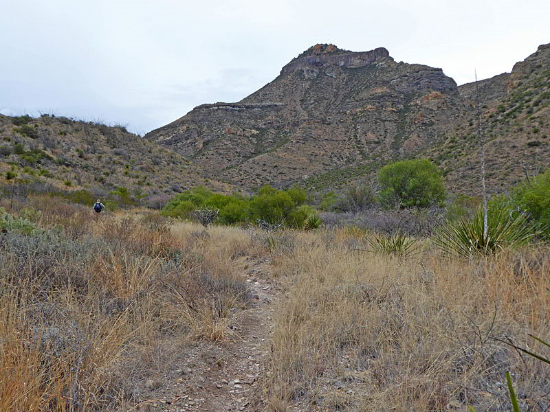
Hikers with the time and energy can extend the hike up the pretty canyon. Beyond the red rock formations the trail continues its steady ascent on moderately-easy grades. As you gain elevation trees start to appear and fine views open to Peak 6728 along with the unnamed summits rimming the north side of the canyon. At 2.8 miles great views open to peak 7150, a light beige and mauve colored mountain.
At 3.6 miles the canyon constricts and the path passes beneath an interesting, highly eroded wall rising above the north side of the canyon. This is a good place to turn around and return to the trailhead for a satisfying 7.2 miles hike.
Beyond this point the trail leaves the canyon floor at 4.2 miles and starts switchbacking steeply up the canyon’s east slopes and then turns north, continuing the climb up the canyon’s headwall. After gaining over 1,200-ft. the trail reaches the Laguna Meadows junction along the South Rim Loop in the Chisos Mountains at 5.5 miles (11.0 miles round-trip from the trailhead).
Note: With a previously arranged car shuttle it is possible to ascend the Laguna Meadows trail from Chisos Basin and then descend the Blue Creek trail to Ross Maxwell Scenic Drive, or vis-versa, for a 9.2 mile hike. See the South Rim Loop trail description for information on the Laguna Meadows trail. The Blue Creek trail is also part of the 27-mile Outer Mountain Loop, a multi-day backpacking trip.
Elevation Profile
Driving Directions
From the Big Bend National Park Headquarters at Panther Junction: From Panther Junction, at the intersection of the Persimmon Gap Road and the West Entrance Road, head west on the West Entrance (Gano Springs) road toward Basin Junction. Follow the road for 12.7 miles and then turn left on the Ross Maxwell Scenic Drive. Drive 8.1 miles on the Ross Maxwell road to a pull-off along the left (east) side of the road signed for the Homer Wilson Ranch and Blue Creek Canyon trail.
From the Chisos Mountain Lodge area: Head northeast on Chisos Basin Road for 6.4 miles and then turn left onto the West Entrance Road. Follow the West Entrance Road for 9.5 miles and the turn left onto the Ross Maxwell Scenic Drive. Drive 8.1 miles on the Ross Maxwell road to a pull-off along the east side of the road signed for the Homer Wilson Ranch and Blue Creek Canyon trail.
Trail Resources
- Trail Photo Gallery
- Trail Maps
- Basecamp(s) Information: Big Bend
- Region Information: Texas Parks
- Other Hiking Regions in: Texas