Murren to Griesalp via the Sefinenfurgge 
Distance: 10.4 miles (one way)
near Lauterbrunnen in The Bernese Oberland
Great views of the Wetterhorn, Eiger, Monch and Jungfrau
This splendid hike over Sefinenfurgge Pass, the second highest pass on the Alpine Pass Route, enjoys impressive views of the high peaks towering above the Lauterbrunnen, Sefinen and Kiental Valleys.
See Trail Detail/Full Description
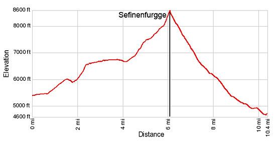
- Distance: 6.0 miles (one way) to Sefinenfurgge
10.4 miles (one way) to Griesalp (Complete Hike) - Elevation: 5,380-ft. at Trailhead
8,570-ft. at Sefinenfurgge
4,620-ft. at Griesalp (Complete Hike) - Elevation Gain: 3,190-ft. to Sefinenfurgge
-3,950-ft. to Griesalp (Complete Hike) - Difficulty: strenuous
- More Hikes in:
Lauterbrunnen / Griesalp / The Bernese Oberland
Why Hike Murren to Griesalp via the Sefinenfurgge
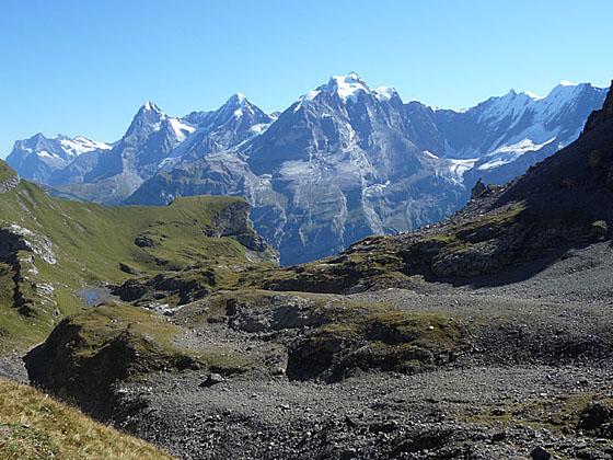
The trail over the Sefinenfurgge, the second highest pass on the Alpine Pass Route, traverses beautiful meadows with breathtaking views of the high peaks towering above the Lauterbrunnen, Sefinen and Kiental Valleys.
After a walk through Murren, set on a sunny shelf high above Lauterbrunnen, the trail ascends through pastures and past small farms on the outskirts of the resort. Great views of the big three, the Eiger, Monch and Jungfrau, are your constant companion. After a short, steep climb up the head of the Wasenegg ridge, the trail enters the Sefinental (Sefinen Valley) where an overlook showcases the Tschingelspitz, Gspaltenhorn and Butlasse towering above the head of the valley.
A beautiful path now contours through pastures along the valley’s north slopes to Rotstock Hut. Beyond the hut a steep trail ascends pretty meadows and then scree covered slopes to the Sefinenfurgge Pass (8,570-ft.), a small notch on a knife-edge ridge. Here we enjoy your last views of the Wetterhorn, Eiger, Monch and Jungfrau. To the west new vistas open to the Armighorn and Dundenhorn rising above the west side of the Kiental. Looking south the Bluemlisalp massif rises above a low ridge.
A very steep trail, with the initial section dropping down wood steps with rope handholds, descends to rocky meadows and then drops steeply down to the Kiental Valley floor. Along the way enjoy great views of the Gspaltenhorn, Morgenhorn and Bluemlisalp massif at the head of the valley. An easy trail now travels along the valley floor, passing through small hamlets on its way to Griesalp, a small village with accommodations and a few restaurants.
Be forewarned that the trails on either side of the pass are quite steep. Be especially careful descending the wood stairs dropping down the west side of the pass. The stairs are extremely slick if wet or covered with snow or ice. If in doubt, turn around.
Please note: There are limited accommodations in Griesalp. I strongly recommend making reservations ahead of time during the peak summer hiking season.
Elevation Profile
| Support our Site |
Trail Resources
Trail Detail/Full Description / Trail Photo Gallery / Trail Map
Basecamp(s) Information:
Lauterbrunnen / Griesalp
Region Information:
The Bernese Oberland
Other Hiking Regions in:
Switzerland