Details: Sheepherder Lakes 
Distance: 4.2 - 6.3 miles (round trip)
Shoshone National Forest, near Cooke City in Beartooth Mountains
Hike Facts
- Distance: 4.2 - 6.3 miles (round trip)
- Elevation: 9,675-ft. - 10,260-ft.
- Elevation Gain: 155-ft. - 585-ft.
- Difficulty: moderate
- Trail Highlights: See Trail Intro
- Basecamp(s): Cooke City / Red Lodge
- Region: Beartooth Mountains
This little known hike travels through lovely meadows to seven scenic lakes along the east side of the Beartooth Plateau. The hike follows use/social trails and then travels cross country. Route finding skills and a map are essential.
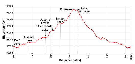
Trailhead to Upper Sheepherder Lake
Distance from Trailhead: 4.2 miles (round trip)
Ending/Highest Elevation: 9,830-ft.
Elevation Gain: 155-ft.
This hike follows use/social trails and then cross country routes to visit seven lakes nestled beneath the ridge delineating the eastern end of the Beartooth Plateau. Carry a map and make sure at least one member of your party is skilled at off-trail navigation. When following a route always turn around to find landmarks for the return journey. The route always looks much different on the return to the trailhead.
The hike starts at the southwestern end of Long Lake near a small tarn. (See driving directions below). Note the line of trees to the west of the tarn. From the trailhead, walk northwest on the dirt jeep road, closed to vehicles, for a short distance to a pullout on the right. Here you should see a faint trail heading northwest toward the trees.
The trail swings around to the left (west) side of the cluster of trees and then heads north through meadows, staying to the left of the trees. Soon the path curves left (northwest) and crosses a stream at 0.2 miles. This is the outlet stream for Dorf Lake to the north. The trail fades in the boggy meadows around the crossing but become clear again on the west side of the creek.
Travel along the west side of the creek, reaching foot of Dorf Lake at 0.4 miles. Views stretch across the pretty lake to the 10,000-ft. peaks rising to the northeast. The path skirts the west side of the lake and then gently ascends along the west side of the inlet stream to foot of an unnamed lake at 0.8 miles.
Here the path heads north through meadows sprinkled with wildflowers and rock outcropping, avoiding the marshy terrain around the lakeshore. A gentle climb soon leads to the western shore of Lower Sheepherder Lake at 1.7 miles.
At times the trail fades as it crosses marshy areas around small streams passed along the route. If you lose the trail remember that the inlet stream for the unnamed lake you just left is the outlet stream for Lower Sheepherder Lake. Travel up steam, staying to the left of the stream to avoid marshy areas, and you will soon find the lower lake.
Now comes the cross country portion of the hike. Upper and Lower Sheepherder Lakes are linked by their inlet/outlet stream. Walk north/northwest along the shore of Lower Sheepherder Lake. Climb through rocky meadows on moderate grades up the hill at the head of the lake, staying a good distance to the west of the inlet/outlet stream.
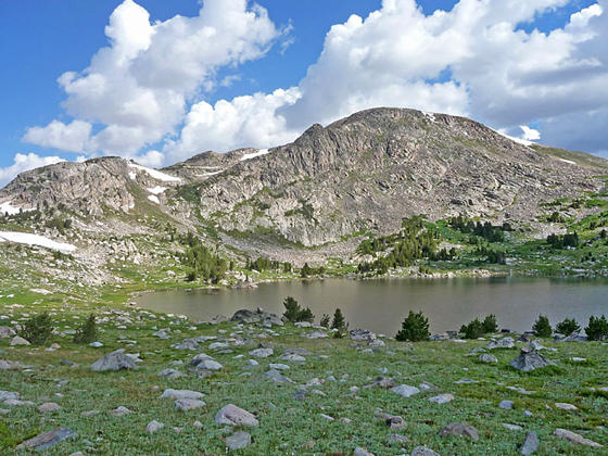
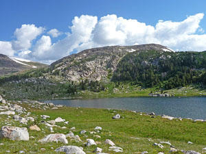
At 2.1 miles the grade abates as the trail reaches the southwest shore of Upper Sheepherder Lake. Peak 11,701-ft. towers above the north side of the upper lake. Stunted conifers grow amid the rocky meadows. The scenic Upper Lake is a great turn around destination for parties looking for a shorter day or anyone not comfortable with further cross country exploration.
From Upper Sheepherder to Snyder, Promise and Z Lake
Distance from Trailhead: 6.3 miles (round trip)
Ending/Highest Elevation: 10,260-ft.
Elevation Gain: 585-ft.
Looking at the map you will now see a trio of lakes with easy reach of Upper Sheepherder Lake. Snyder Lake is the easiest lake to find. From the southwestern corner of Upper Sheepherder Lake simply walk west on gentle grades. When you see Snyder Lake drop down rocky meadows to the head of the lake at 2.5 miles.
There are two lakes to the north of Snyder, Z Lake and Lake Promise. To find these lakes, walk right (west) along the head of Snyder Lake to a rocky draw. Turn right (north) and climb moderate grades through meadows and talus slopes along the right (east) side of the draw, avoiding the boulder fields in the center of the draw. To avoid the worst of the boulders at the head of the draw, climb out of the draw and then continue heading north through scattered conifers and meadows above the east side of the draw.
Soon views open right (southeast) to Upper Sheepherder Lake, nestled in a basin below our route. A small pond lies in a marshy depression beneath a granite knoll. You are now at the confluence of three draws (2.8 miles). To the right (southeast) is a draw dropping down to Upper Sheepherder’s Lake. Behind you is the draw dropping down to Snyder Lake. To your left (north) is a draw climbing north/northwest to Lake Promise.
Head north through brushy meadows at the confluence of the three draws. Soon a trail appears. Follow the trail as it ascends north on moderate grades along the east side of the draw. Soon the trail fades. Pick the path of least resistance, avoiding the worst of the talus fields by staying in the rocky meadows.
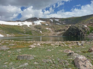
At 3.2 miles reach the south shore of Lake Promise at 3.2 miles. The lake is tucked in a small bowl beneath an interesting ridge rimming the eastern edge of the Beartooth Plateau. Walk west/southwest from Lake Promise, ascending a low hill to an overlook above pretty Z Lake at 3.3 miles. Here views stretch west/southwest to the corrugated landscape of granite knolls and ridges of the Beartooth Plateau. The Absaroka Mountains fill the skyline to the south.
When you are done enjoying Lake Promise and Z Lake, retrace your steps to the confluence of the three draws. Here we bear left (southeast), dropping through meadows above the western shore of Upper Sheepherder Lake. At the end of the upper lake, descend the rocky meadows to Lower Sheepherder Lake.
Traverse the western shore of the lower lake. Near the foot of the lake bear right (southwest), heading back to the unnamed lake. If you lose the trail, walk above the west side of the outlet stream, which becomes the inlet stream of the unnamed lake. Stay to the west above the stream to avoid marshy meadows. Soon you should pick up the use/social trail back to the trailhead at Long Lake.
Again, let me emphasize to turn around as you hike to pick out landmarks to facilitate route finding on your return journey. It is amazing how different a trail looks when you walk it in the opposite direction. Always carry a map and know how to use it.
Please don’t attempt this hike if you are not versed on route finding and don’t have a map.
Elevation Profile
Driving Directions
From Cooke City, MT: Drive east on US 212 E (the Beartooth Highway) for 27 miles and turn left at the turnoff just before Long Lake (Forest Road 1522A). The short spur road leads to a parking area. The trail starts by following a closed jeep road, located at the northwest end of the parking area.
From Red Lodge, MT: Drive southwest on US 212 W (the Beartooth Highway) for 36.6 miles and turn right at the turnoff right after Long Lake (Forest Road 1522A). The short spur road leads to a parking area. The trail starts by following a closed jeep road, located at the northwest end of the parking area.
Trail Resources
Trail Intro / Trail Photo Gallery / Trail Map
Basecamp(s) Information:
Cooke City / Red Lodge
Region Information:
Beartooth Mountains
Other Hiking Regions in:
Montana