Lakes Trail - Heather, Emerald and Pear Lakes 
Distance: 8.2 - 12.8 miles (round trip)
Sequoia-Kings Canyon National Park, near Lodgepole in California's Southwestern Sierra
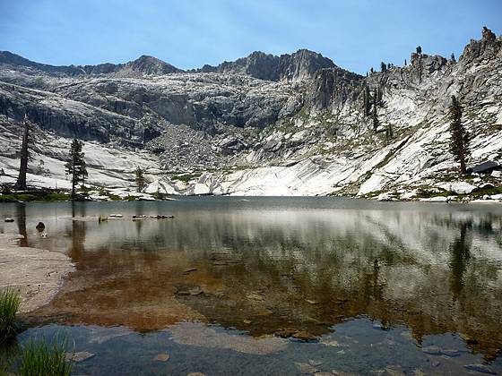
Alta peak rises above the southern end of Pear Lake.
The Lakes Trail, one of the most popular hikes in Sequoia National Park, climbs through dense forest to a landscape of polished granite dotted with four beautiful lakes and set amid a backdrop of rugged ridges anchored by Alta Peak (11,204-ft.).
See Trail Detail/Full Description
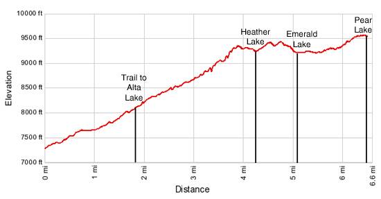
- Distance: 8.2 miles (round trip) to Heather Lake
10.6 miles (round trip) to Emerald Lake
12.8 miles (round trip) to Pear Lake - Elevation: 7,280-ft. at Trailhead
9,280-ft. at Heather Lake
9,230-ft. at Emerald Lake
9,550-ft. at Pear Lake - Elevation Gain: 2,000-ft. to Heather Lake
2,170-ft. to Emerald Lake
2,490-ft. to Pear Lake - Difficulty: moderate-strenuous
- More Hikes in:
Lodgepole / California's Southwestern Sierra
Why Hike Lakes Trail - Heather, Emerald and Pear Lakes
Amazing views of the Marble Fork of the Kaweah Canyon and four beautiful lakes set amid glacier carved basins framed by sheer granite cliffs and rugged ridges are a few of the scenic rewards for this long day hike located to the east of Lodgepole in Sequoia National Park. The trail, one of the most popular in the park, climbs through dense forest to a landscape of polished granite dotted with lakes and framed by the rocky ridges extending from Alta Peak (11,204-ft.).
The four lakes along the trail are all worthy destinations. Pleasant little Heather Lake (9,280-ft.), the first lake, is reached 4.1 miles from the trailhead. A mile beyond is lovely Aster Lake and shortly thereafter Emerald Lake, tucked in a scenic glacier carved bowl beneath Alta Peak and its adjoining jagged ridges. Beautiful Pear Lake, a 1.1 miles past Emerald, is set amid a world of glacial polished granite slabs and cliffs framed by Alta Peak to the south.
The lakes are best visited on a long day hike. So pick a promising day and get an early start to enjoy this gorgeous place. Note that high demand for the limited number of camping spots along the Lakes Trail makes it difficult to obtain a backpacking permit.
Elevation Profile
Trail Resources
Trail Detail/Full Description / Trail Photo Gallery / Trail Map
Basecamp(s) Information:
Lodgepole
Region Information:
California's Southwestern Sierra
Other Hiking Regions in:
California