Palatki Heritage Site 
Distance: 1.5 miles
Red Rock Secret Mountain Wilderness, Coconino National Forest, near Sedona in Arizona's Red Rock Country
Palatki Ruins
Bear Mountain towers above a beautiful canyon where alcoves and overhangs in the red rock formations protect Sinagua cliff dwellings and rock art. Three easy trails offer visitors access to the Palatki Heritage Site, reached by a rough road that requires a vehicle with good clearance.
- Distance: 1.5 miles (RT)
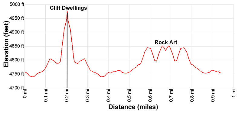
- Elevation: 4,740-ft. at Trailhead
Maximum elevation - 4,976-ft. - Elevation Gain: 236-ft.
- Difficulty: easy
- Basecamp: Sedona
- Region: Arizona's Red Rock Country
Trail Description - Palatki Heritage Site
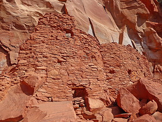
The Palatki Heritage site, located in a canyon to the north of Sedona, contains well preserved Sinagua cliff dwellings and an interesting rock art panel. The site, along with nearby Honanki Heritage Site, were occupied between 1150 and 1350 and are believed to be the largest cliff dwellings the area. It is a beautiful setting with Bear Mountain towering above Palatki’s red rock cliffs.
The two sites were first visit in 1895 by Walter Fewkes, a famous turn-of-the century archaeologist from the Smithsonian Institution. He is credited with giving Honanki (Bear House) and Palatki (Red House) their Hopi names. The Hopi, however, have no specific names for these sites.
The Palatki site, home to about 60 people, is accessed by two trails, one leading to the cliff dwellings and one to the rock art. Visitors must make a reservation to visit the site by calling (928) 282-3854. Knowledgeable forest service employees and volunteers are located at the cliff dwelling and the rock art sites to offer insights into the structures, rock art and how the people lived.
From the parking area a short trail with interpretive signs include information about the site, the Sinagua people and the trails. This short detour soon leads to a broad path to the information Visitor Center where you sign. Just beyond the visitor center is a trail junction where the trails to the ruins and rock art start.
At the junction the trail to the right (east) ascends gently to the base of the cliff. Here rock stairs zigzag up to the alcoves containing the cliff dwellings. The remains of the multi-story dwellings provide insights into building techniques. Pottery shards, small corn cobs and metates (grinding stones) are scattered around the area. High on the wall of the alcove are pictographs of round shields.
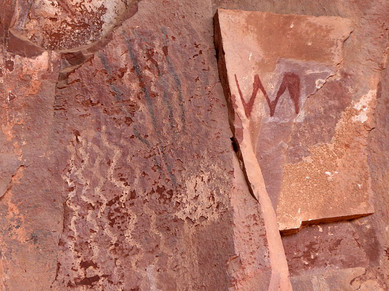
When you are done enjoying the ruins return to the junction and take the trail heading southwest. This path gently ascends along the edge of the cliffs and then climbs some stone steps to gain access to the grotto, tucked beneath an overhang. Here you will see a wide variety of pictographs
Beyond the rock art is an area closed to visitor that contains the temporary residence of Charles Willard. He used the dwelling between 1923 and 1925. The walls appear to be in good shape but most of the roof is gone although the chicken-wire used to support the roof structure is still in place.
After viewing the rock art return to the trail junction for a 1.0 miles hike. This mileage does not including the 0.25 round trip journey from the parking lot to the visitor center.
There is one other trail at the site, called the Palatki Vista trail, which starts from the parking area. This broad track travels through meadows to a viewpoint beneath the cliff dwellings. Along the way enjoy fine views of Bear Mountain rising to the northeast. Past the viewpoint the trail connects with the cliff dwellings trail and then returns to the visitor center and the parking lot. The loop is about 0.5 miles and a good alternative for visitors who don’t want to climb the stone steps to view the ruins.
Elevation Profile
Driving Directions
Driving Directions from Sedona: From the traffic circle at the intersection of State Routes 89A and 179 head west on Arizona 89A for 9.6 miles and turn right onto Forest Road 525 / Loy Butte Road. The turn is just past mile marker 365. Follow Forest Road 525 for 5.0 miles. When Forest Road 525 bears left, continue straight ahead onto Forest Road 795 for two miles. This road will lead directly into the Palatki parking lot
Alternatively, those with high-clearance vehicles and/or a sense of adventure can turn right on Dry Creek Road off 89A and follow the signs for Enchantment Resort/Loy Butte. At the road to the Enchantment Resort, turn left onto Boynton Pass Road (FR 152C). At the next stop sign, turn left again. In a couple of miles, the pavement will end and you should continue on the rough gravel road for three miles until you reach another “T” intersection where you should turn right. It is 2 miles to Palatki from this intersection. These roads are generally passable to passenger cars when dry, but they are not regularly maintained by the County and have some rough and rocky stretches.
Note: a Red Rock Pass, America the Beautiful Interagency Pass, Golden Age Pass or Golden Access Pass is required to park in the lot. Red Rock Daily passes are $5, weekly passes are $15 and annual passes are $20. There is a machine at the parking area to purchase the pass. Passes can also be purchased in many shops around Sedona or online.
Trail Resources
- Trail Photo Gallery
- Trail Maps
- Basecamp(s) Information: Sedona
- Region Information: Arizona's Red Rock Country
- Other Hiking Regions in: Arizona