Iceline Trail 
Distance: 8.6 - 12.6 miles (loop)
Yoho National Park, near Yoho in The Canadian Rockies
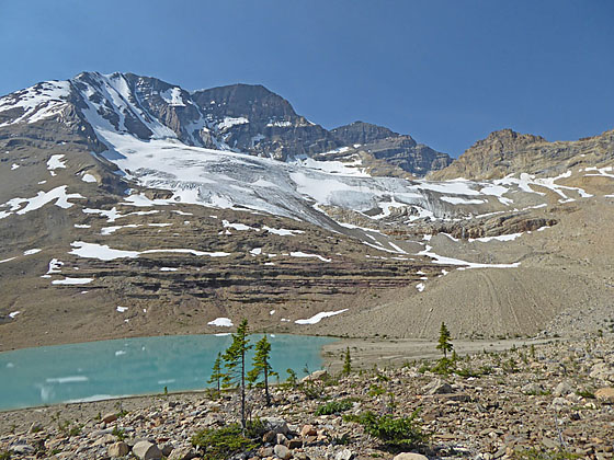
The Vice President, the President and Emerald Glacier
One of the premier hikes in Yoho National Park features grand views of glacier clad peaks, rugged alpine landscapes and dramatic waterfalls.
See Trail Detail/Full Description
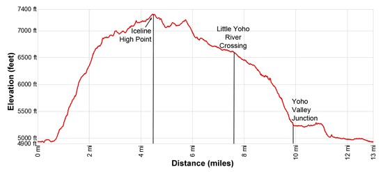
- Distance: 8.6 miles (round trip) to Iceline High Point
12.6 miles (loop) to Complete Loop - Elevation: 4,930-ft. at Trailhead
7,310-ft. at Iceline High Point
7,310-ft. at Complete Loop - Elevation Gain: 2,380-ft. to Iceline High Point
-2,380-ft. to Complete Loop - Difficulty: strenuous
- More Hikes in:
Yoho / Field / The Canadian Rockies
Why Hike Iceline Trail
Spectacular views of high peaks, glaciers and waterfalls are the highlights of this must-do loop hike in Yoho National Park. The trail, starting near Takakkaw Falls, climbs to and traverses a high bench with inspiring views of the glacier clad summits towering above the Yoho and Little Yoho Valleys. At the end of the traverse the trail drops to the meadows of the Little Yoho Valley and then returns to the trailhead via the Yoho Valley Trail with side trips to Laughing, Point Lace, Angel’s Staircase and Takakkaw Falls.
The trail can be done as an out-and-back hike to the high point along the trail (8.6 miles round-trip) or as a loop (13 miles round-trip). Both options are strenuous hikes over rugged terrain with dramatic scenery. If time and energy allow hike the loop to see the high peaks soaring above the emerald green meadow of the Little Yoho Valley and sample some or all of the waterfalls along the Yoho Valley.
Elevation Profile
Trail Resources
Trail Detail/Full Description / Trail Photo Gallery / Trail Map
Basecamp(s) Information:
Yoho / Field
Region Information:
The Canadian Rockies
Other Hiking Regions in:
Alberta / British Columbia