Backpack: Big Sandy to Elkhart Park via Fremont and Highline 
Distance: 53.8 miles (one way)
Bridger Wilderness, Bridger-Teton National Forest, near Big Sandy in Wyoming's Wind River Range
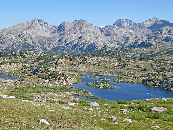
Bald Mountain Basin
Panoramic views of the high peaks along the Continental Divide, lovely lake basins and varied terrain are the hallmarks of this terrific point-to-point backpack along the Fremont and Highline trails.
- Distance: 53.8 miles
- Elevation: 9,085-ft. at Trailhead
9,925-ft. at Junction Fremont and Pyramid Lake Trail
9,755-ft. at East Fork River Crossing
10,565-ft. at Plateau High point
9,970-ft. at South Fork Boulder Creek Crossing
9,850-ft. at Junction Middle Fork Trail
10,320-ft. at High Point above Howard Lake
9,754-ft. at Junction at North Fork Lake
10,848-ft. at Hat Pass
10,225-ft. at Little Fall Creek Crossing
10,860-ft. at Overlook above Bald Mountain Basin
11,060-ft. at Lester Pass
10,400-ft. at Junction Seneca Lake Trail
10,346-ft. at Island Lake
10,300-ft. at Junction Pole Creek Trail
9,340-ft. at Elkhart Park Trailhead - Difficulty: strenuous
- More Hikes in:
Big Sandy / Elkhart Park / Wyoming's Wind River Range
Introduction
Panoramic views of the high peaks along the Continental Divide, lovely lake basins and varied terrain are the hallmarks of this terrific point-to-point backpack along the Fremont and Highline trails. Starting at the Big Sandy trailhead the trip parallels the west side of the Continental Divide, crossing high plateaus and passes with see-forever views, dipping in and out of beautiful lake basins and traveling through expansive meadows sprinkled with wildflowers. The trip ends with a visit to stunning Island Lake before exiting via the Seneca Lake and Pole Creek trails to the Elkhart Park trailhead.
Along the way side trails and routes branching from the Fremont and Highline offer plenty of opportunities to explore the high country along the Divide. Recommended side trips include the Bonneville Lakes, the Middle Fork Valley, Europe Canyon, Hay Pass and the Cook Lakes.
It is impossible to see everything in one trip. After getting a taste of the area you will return year after year, sampling new areas with each visit. Look at this backpack and its associated side trips as a roadmap to get your started on your explorations.
Backpack Segments
- Segment 1: Big Sandy to Marms Lake
- Segment 2: Marms Lake to Raid Lake
- --- Side Trip: Bonneville Lakes
- Segment 3: Raid Lake to Middle Fork Junction above Sandpoint Lake
- --- Side Trip: Middle Fork Lake Trail
- --- Side Trip: Middle Fork Lake via the Rainbow Lake Trail
- --- Side Trip: Photo Pass Trail
- Segment 4: Sandpoint Lake to Valley Lake Junction
- --- Side Trip: Europe Canyon and Pass
- Segment 5: Valley Lake Junction to North Fork Lake
- --- Side Trip: Hay Pass, the Golden Lakes and Fall Creek Pass
- Segment 6: North Fork Lake to Bell Lakes Junction
- Segment 7: Bell Lakes Junction to Pole Creek
- --- Side Trip: Cook and Wall Lakes
- Segment 8: Pole Creek to Little Seneca Lake
- Segment 9: Little Seneca Lake to Island Lake
- --- Side Trip: Titcomb Basin
- --- Side Trip: Indian Basin and Pass
- --- Side Trip: Island Lake Waterfall Hike
- Segment 10: Island Lake to Elkhart Park
Elevation Profile
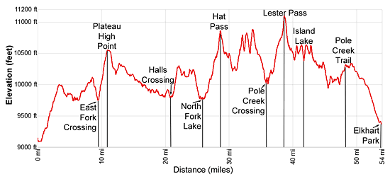
Mileage and Elevation Detail
| Miles | Elevation | Destination | |
|---|---|---|---|
| 0.0 | 9,085-ft. | Big Sandy Trailhead | |
| 0.6 | 9,120-ft. | Junction Sedgewick Meadow / Big Sandy (bear left) | |
| 1.3 | 9,320-ft. | Junction Diamond Lake | |
| 1.5 | 9,355-ft. | Junction Fremont Trail | |
| 5.5 | 9,741-ft. | Dad’s Lake | |
| 6.8 | 9,878-ft. | Marms Lake | |
| 7.4 | 9,925-ft. | Junction with Pyramid Lake Trail | |
| 9.5 | 9,755-ft. | East Fork River Crossing | |
| 11.0 | 10,565-ft. | High point on the Plateau southwest of Mt. Geikie | |
| 12.3 | 10,165-ft. | Cross North Fork Silver Creek | |
| 12.9 | 10,347-ft. | Junction with trail to Cross Lake | |
| 13.8 | 10,238-ft. | Cross Sheep Creek | |
| 15.4 | 10,047-ft. | Cross Raid Creek | |
| 16.5 | 9,970-ft. | Cross South Fork Boulder Creek / Junction Bonneville Lakes Trail | |
| 17.5 | 9,910-ft. | Junction Rainbow Lake Trail | |
| 17.8 | 9,880-ft. | Cross Dream Creek | |
| 18.0 | 9,880-ft. | Bob’s Lake | |
| 19.0 | 9,846-ft. | Sandpoint Lake Beach | |
| 19.5 | 9,850-ft. | Junction Middle Fork Trail | |
| 21.0 | 9,800-ft. | Halls Creek Crossing | |
| 22.2 | 10,320-ft. | High Point above Howard Lake | |
| 23.8 | 10,210-ft. | Junction Valley Lake | |
| 26.2 | 9,754-ft. | Junction at North Fork Lake | |
| 28.6 | 10,848-ft. | Hat Pass | |
| 30.6 | 10,225-ft. | Little Fall Creek Crossing | |
| 31.6 | 10,470-ft. | Junction Bell Lakes Trail | |
| 33.7 | 10,860-ft. | Overlook above Bald Mountain Basin | |
| 34.3 | 10,540-ft. | Enter Bald Mountain Basin | |
| 35.7 | 10,065-ft. | Junction Highline Trail | |
| 38.4 | 11,060-ft. | Lester Pass | |
| 40.3 | 10,400-ft. | Junction Seneca Lake Trail | |
| 40.7 | 10,540-ft. | Junction Indian Pass Trail | |
| 41.7 | 10,346-ft. | Island Lake | |
| 43.1 | 10,400-ft. | Junction Seneca Lake Trail | |
| 46.8 | 10,300-ft. | Junction Pole Creek Trail | |
| 53.8 | 9,340-ft. | Elkhart Park Trailhead |
Trailhead Driving Directions
Big Sandy Trailhead: This popular trailhead is located in the southern Wind River Range next to the Big Sandy River.
Directions from Pinedale: From the intersection of Pine Street (US 191) and North Tyler Ave (the Pinedale Tourism office is located on the northeast corner) in Pinedale, WY, drive south on Highway 191 for 11.7 miles and then turn left (east) on WY-353. After 15.5 miles you will notice signs referring to the road as the Big Sandy-Elkhorn Road and after 18 miles the paved road will change to a good packed dirt/gravel surface.
Shortly after the pavement ends go straight through a junction, and drive south crossing the Big Sandy River (Buckskin Crossing). Follow the road for a total of 27.3 miles. Shortly after crossing the Big Sandy River you will reach a junction with the Lander Cutoff Road (the next junction). Turn left on the Lander Cutoff Road. There is a wood sign at the intersection pointing toward the Big Sandy trailhead.
Drive 7.0 miles on the Lander Cutoff Road and then turn left on the Big Sandy Opening Road. Here you will see a sign for the Big Sandy Campground and trailhead. The road now deteriorates and narrows. Blind corners and lush foliage along the road make it hard to see ahead. Drive carefully, following the rocky, rutted road for 9.8 miles to a "Y" intersection. Bear right at the intersection to continue along the Big Sandy Opening Road (Forest Service Road 850). (The road branching to the left leads to the Big Sandy Lodge and Mud Lake.) Follow the road for 0.8 miles to the trailhead parking area, equipped with an outhouse.
Allow an hour and a half to reach the trailhead from Pinedale. The parking area is too small for the number of backpackers visiting the area during the height of the summer. If the parking area is full, find a safe place to park off the access road.
I recommend a high clearance vehicle to reach the trailhead. Passenger cars can make it OK if driven carefully. Check at the Pinedale ranger station before starting your trip to learn about current road and trail conditions. The Ranger Station is located to the east of the Ridleys Grocery Store on US 191 (Pine Street in Pinedale). The entrance to the ranger station is on the Fremont Lake Road. (You can also reach the parking area for the ranger station by driving east through the Ridley’s parking lot.)
This trailhead is remote, so be sure to have a full tank of gas. The dirt road become slippery when wet. The campground at the parking area is tiny, with only 4 sites. I would not plan on camping at the trailhead before starting your backpack.
Elkhart Park Trailhead: From the intersection of Pine Street (US 191) and North Tyler Ave (the Pinedale Tourism office is located on the northeast corner) in Pinedale, WY, drive east on Highway 191 (East Pine Street) for 0.3 miles and bear left onto Fremont Lake Road. Follow this road for 14.3 miles and turn right into the large parking area for the Elkhart Park/Pole Creek Trailhead. After the first 3.0 miles the road will turn into Skyline Drive/Forest Service Road 370740. The trailhead is located at the northeast end of the parking lot between the outhouse and the trailhead kiosk. It should take about 25 minutes to drive the trailhead. The last section of the road has some holes and uneven spots.
Trail Resources
Trail Photo Gallery / Trail Map
Basecamp(s) Information:
Big Sandy / Elkhart Park
Region Information:
Wyoming's Wind River Range
Other Hiking Regions in:
Wyoming