Hidden Valley
Fine views of the Behind the Rocks and the La Sal Mountains along with the option to see great rock art panels make this a recommended hike.
See Trail Detail/Full Description
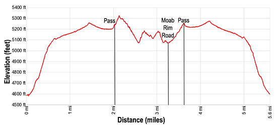
- Distance: 5.6 miles (round trip) to Hidden Valley
- Elevation: 4,580-ft. at Trailhead
5,325-ft. at Hidden Valley - Elevation Gain: 745-ft. to Hidden Valley
- Difficulty: moderate
- More Hikes in:
Moab / Southeast Utah
Why Hike Hidden Valley
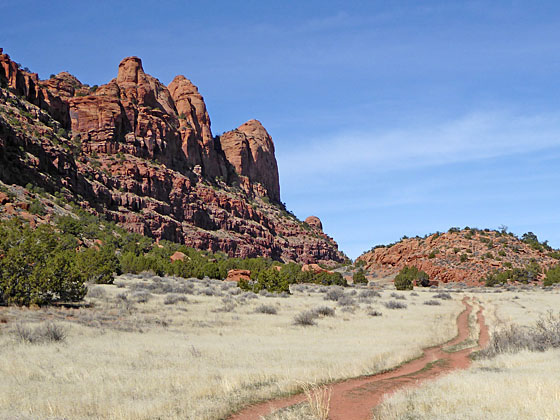
To the southwest of Moab seemingly impenetrable cliffs, known as the Moab Rim, tower above the western side of the Spanish Valley. The Hidden Valley trail climbs steeply midway up the wall to a breach in the cliffs where a broad shallow shelf, hidden from view, ascends to a pass with great views of the Behind the Rocks area and the La Sal Mountains.
Beyond the pass use trails lead to excellent rock art panels. Extend the hike with a car shuttle by hiking down to the Moab Rim Trail, a difficult 4WD road, and then descend the road to the Kane Creek Road along the Colorado River.
There is little to no shade on the climb up to the pass. My advice is to get an early start to complete the climb to the pass before it gets hot. Alternatively, do the hike late in the day when the Moab Rim partially shades the trail.
The Moab Rim Trail is a very popular with off-highway vehicle enthusiasts. Some hikers find it entertaining to watch the vehicles negotiate the steep slickrock sections of the trail. Others don’t like the dust and traffic that includes mountain bikes. The trail is most crowded on the weekends and should be avoided during the Moab Jeep Rally.
Elevation Profile
Trail Resources
Trail Detail/Full Description / Trail Photo Gallery / Trail Map
Basecamp(s) Information:
Moab
Region Information:
Southeast Utah
Other Hiking Regions in:
Utah