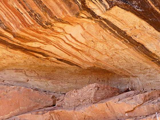
View of the upper level of Double Stack Ruin
Ruins, rock art and two sweat lodges are the highlights of this short hike in a brushy canyon to the west of the Lower Butler Wash Road.
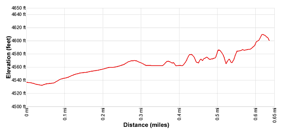
- Distance: 1.3 miles (RT)
- Elevation: 4,530-ft. at Trailhead
Maximum elevation - 4,610-ft. - Elevation Gain: 80-ft.
- Difficulty: easy
- Basecamp: Bluff / Bears Ears NM
- Region: Southeast Utah
Trail Description - Double Stack Ruin
Comb Ridge is a stunning sandstone ridge of steeply tilted rock layers called a Monocline, a step-like fold in the rock strata. The ridge runs north-south for approximately 80 miles from Utah’s Abajo Mountain to Kayenta, Arizona. The jagged appearance of the ridge is similar to a rooster’s comb, hence the name.
The Lower Butler Wash Road, paralleling the base of the ridge to the east, offers access to the ridge and its drainages renowned for prehistoric sites, including ruins and rock art. Double Stack ruin is a recommended stop along the road.
The biggest challenge when visiting the sites along Butler Wash is finding the correct trailhead. There are no signs marking turnoffs to the various drainages. When looking for trailheads your best bet is to religiously keep track of your mileage as you progress up or down the road. (See the driving directions below for more information.)
At the northwest end of the unmarked trailhead parking area, a boot beaten path heads west, dipping into and then climbing out of Butler Wash. Ignore the cow trails that follow the wash upstream/downstream.
Beyond Butler Wash the trail travels northwest through scrub, crossing a small gully at 0.1 miles. A tenth of a mile beyond the trail reaches slickrock where rock cairns mark the continuation of the route.
After 0.3 miles the trail descends into a canyon. The boot beaten path now crosses the canyon’s wash and then turns left (west) on a bench as it heads up canyon. Soon you will pass an old sweat lodge or wikiup constructed of branches. Please don’t touch this fragile structure.
For the rest of the hike the trail along the benches above the canyon’s wash, occasionally crossing the wash to find the path of least resistance up the brushy canyon. At 0.6 miles pass a second sweat lodge or wikiup that is in poor shape. Ahead views open to the upper level of Double Stack Ruins. This section of the alcove is inaccessible.
Soon you will see the ruins in the lower section of the alcove, surrounded by a wood fence. A sign marks the opening in the fence where you may enter the ruins. The fence is intended to protect fragile areas of the site.
When visiting the Double Stack ruins please treat all the archaeology you discover with reverence and respect so that it may be enjoyed by future generations. Do not sit, climb or step on the walls of any structures or attempt to enter the structures. Leave any pot shards, corn cobs or other relics where you found them. Remember that rock art is extremely fragile and easily damaged. Never touch rock panels as the oil on your fingers can speed the erosion of the rock art. Do not vandalize the panels by taking latex mold prints or rubbings from rock art or adding modern additions. Please see the Tips for Enjoying and Preserving Archaeology Sites for more information.
Double Stack is a good size site with ruins in various states of decay. A few nice walls still stand along with some smaller structures. Red, yellow and white pictographs are found on the alcove’s walls. Pottery shards and corn cobs are scattered about the alcove. Please leave them where you found them.
When you are done investigating the ruins retrace your steps to the trailhead for a 1.3 miles round-trip hike.
Elevation Profile
Driving Directions
The surface of Utah County Road 262, the Butler Wash Road, is packed dirt with sections of slickrock. The road, which can be rutted, sandy and rough in place, is passable with a 2WD vehicle if driven carefully. High clearance or 4WD is better.
Mileage may vary for numerous reasons. The mileage below was tracked from the intersection of US 162 and County Road 262 (aka Lower Butler Wash road.) I have also provided GPS coordinates of the spur road leading to the unmarked trailhead.
From Bluff: Drive southwest on US-191 S for 4.2 miles. Where US-191 turns south continue straight ahead on US 162 for 0.9 miles and turn right on County Road 262 / Lower Butler Wash Road. The road is located between mile posts 41 and 40 and is across from the Bluff Airport Road (County Road 269A). Almost immediately reach a gate across the road, secured by a chain. Make sure you close the gate after passing through. At 3.9 miles reach a spur road on the left [~GPS location: 37.315768, -109.627956]. Turn onto the spur road, ignoring the road branching off to the left. Almost immediately the road splits. Bear right and drive a short distance to a parking area.
From Mexican Hat: Drive east on US-163 for 19.6 miles and turn left on County Road 262 / Lower Butler Wash Road. The road is located between mile posts 41 and 40 and is across from the Bluff Airport Road (County Road 269A). Almost immediately reach a gate across the road, secured by a chain. Make sure you close the gate after passing through. At 3.9 miles reach a spur road on the left [~GPS location: 37.315768, -109.627956]. Turn onto the spur road, ignoring the road branching off to the left. Almost immediately the road splits. Bear right and drive a short distance to a parking area.
Trail Resources
- Trail Photo Gallery
- Trail Maps
- Basecamp(s) Information: Bluff / Bears Ears NM
- Region Information: Southeast Utah
- Other Hiking Regions in: Utah