Kachina Bridge 
Distance: 1.4 miles
Natural Bridges National Monument, near Blanding in Southeast Utah
Kachina Bridge in the Spring
Descend to the floor of Armstrong Canyon for great views of the Kachina Bridge, a massive sandstone structure at the junction of White and Armstrong Canyons. Rock art and nearby ruins add interest to the hike.
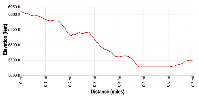
- Distance: 1.4 miles (RT)
- Elevation: 6,020-ft. at Trailhead
Maximum elevation - 5,650-ft. - Elevation Gain: -370-ft.
- Difficulty: moderate-strenuous
- Basecamp: Bears Ears NM / Natural Bridges NM
- Region: Southeast Utah
Trail Description - Kachina Bridge
Natural Bridges National Monument (6,200-ft), situated high atop Cedar Mesa, illustrates the power of water in shaping a high desert landscape. Intermittent streams have cut two deep canyons; White and Armstrong, and three massive sandstone bridges; Sipapu, Kachina and Owachomo, formed from what was once the shore of an ancient sea that covered the area.
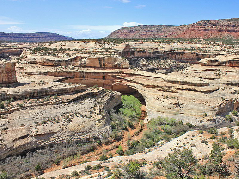
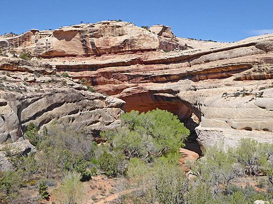
The Kachina Bridge, situated between Sipapu and Owachomo Bridges, is in Armstrong Canyon at its confluence with White Canyon. The bridge’s name comes from a petroglyph called a Kachina, a sacred dancer of the Hopi Indians, carved into the underside of the structure.
Kachina, while not a large as Sipapu, is the most massive of the bridges with a thickness of 93-ft. and a width of 44-ft. The bridge has a span of 204-ft. and a height of 210-ft. In comparison Sipapu boasts a span of 268-ft. and a height of 220-ft.
The trail to the Kachina Bridge starts at the Kachina Overlook parking area. (See driving directions below.) Follow the paved path toward the Kachina Bridge Viewpoint as it descends on easy grades for 300-ft. to a junction with the trail to Kachina Bridge. Turn left on the trail to the bridge.
The well-engineered trail descends switchbacks down a slickrock and packed sand trail along the east side of Armstrong Canyon. The descent is facilitated by wood and rock steps and a wood ladder. In places metal railings and chiseled steps ease the descent down steep friction pitches.
The hike is accompanied by fine vistas of Armstrong Canyon and Deer Flat Mesa to the north. Views of Kachina Bridge, along the floor of Armstrong Canyon, are partially obstructed by several large cottonwoods growing along a bench on the west side of the canyon.
The descent is initially on moderate to moderately steep grades. After 0.3 miles the grade steepens until the trail reaches the junction with the canyon trail at 0.4 miles. (This trail is part of the Natural Bridges Loop Trail.. To the left is the trail up Armstrong Canyon to Owachomo Bridge. We turn right on the trail heading down Armstrong Canyon toward Kachina Bridge. Ahead are fine views of the bridge.
The path briefly travels along a slickrock bench before making the final steep drop to the floor of the canyon. Metal railings, a wood ladders and steps chiseled in the steep slickrock slope facilitate the steep descent. A final set of wood steps eases the way to the canyon floor. Make note of this junction so you do not miss the trail climbing back to the trailhead. (A number of unofficial paths continue up the Armstrong Canyon wash to a scenic pour-off.)
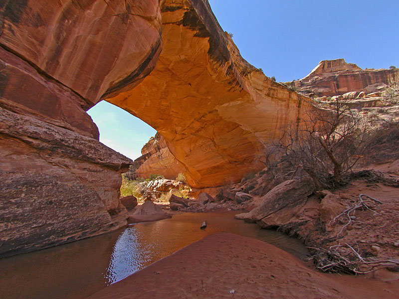
A boot beaten path now heads northwest, crosses to the west side of Armstrong Canyon and then travels along a bench to the Kachina Bridge. Only when you are standing under the massive structure do you gain an appreciation of it size. From this vantage point you can understand why the Paiute referred to the bridge as “under the horse’s belly.”
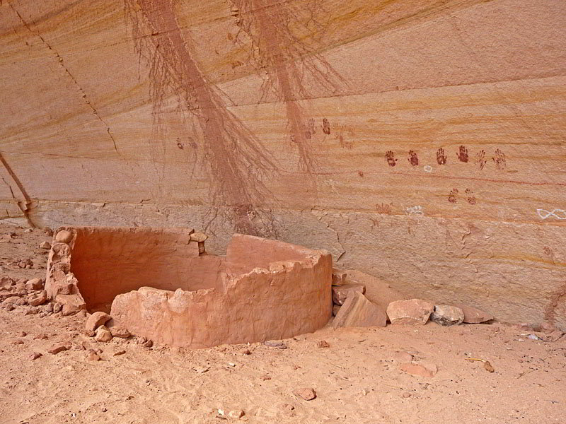
Look for petroglyphs and some pictographs along the right (east) side of the bridge. The figures, depicting animals, humans and abstract shapes, were created by ancestral Puebloans over 700 years ago. To the southwest of the bridge is a steep sandy slope where trails lead to a small ruin and more rock art. Please help protect any rock art you discover. Refrain from touching, drawing, or marking the images. Don’t sit on the walls, touch or otherwise damage any ruins you may find while exploring the area around the bridge.
When you are done viewing the arch and the nearby rock art/ruins, retrace your steps to the trailhead. On the way back you can take a short hike up the canyon to the base of an interesting pour-off. Once back on the rim, take the short walk to the Kachina Viewpoint for bird’s-eye-views of the bridge.
Elevation Profile
Driving Directions
From Blanding: Drive south on US 191 S for 4 miles and then turn right (west) on UT-95 N. Follow UT-95 for 30.2 miles and then turn right (north) on UT-275 N, signed for Natural Bridges. Follow UT-275 N for 4.5 miles to the Visitor Center, on the right, where you need to pay the entrance fee for the national monument. After paying the fee continue on UT-275 for 0.5 miles to a “T” intersection and turn right on the one-way loop road circling the monument. Drive along the loop road for 4.1 miles to the Kachina Bridge Viewpoint trailhead parking area.
From Bluff: From the corner of N 6th Steet and US-191 in Bluff, head north on US-191 for 21.8 miles and then turn left (west) on UT-95 N. Follow UT-95 for 30.2 miles and then turn right (north) on UT-275 N, signed for Natural Bridges. Follow UT-275 N for 4.5 miles to the Visitor Center, on the right, where you need to pay the entrance fee for the national monument. After paying the fee continue on UT-275 for 0.5 miles to a “T” intersection and turn right on the one-way loop road circling the monument. Drive along the loop road for 4.1 miles to the Kachina Bridge Viewpoint trailhead parking area.
From Mexican Hat: Head east on US 163 N for 3.9 miles and then turn left (north) on UT 261 N. Follow UT261 N for 32.7 miles to its end at UT 95. (Note: a short section of UT-261 climbs steep gravel switchback up the Moki Dugway.) Turn left (west) on UT 95 N. Follow UT 95 N for 1.8 miles and turn right (north) on UT-275 N, signed for Natural Bridges. Follow UT-275 N for 4.5 miles to the Visitor Center, on the right, where you need to pay the entrance fee for the national monument. After paying the fee continue on UT-275 for 0.5 miles to a “T” intersection and turn right on the one-way loop road circling the monument. Drive along the loop road for 4.1 miles to the Kachina Bridge Viewpoint trailhead parking area.
Trail Resources
- Trail Photo Gallery
- Trail Maps
- Basecamp(s) Information: Bears Ears NM / Natural Bridges NM
- Region Information: Southeast Utah
- Other Hiking Regions in: Utah