Chimney Rock Loop 
Distance: 3.6 miles
Fruita District, Capitol Reef National Park, near Capitol Reef in South Central Utah
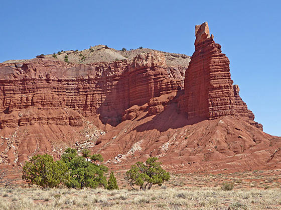
Chimney Rock
This scenic hike ascends the mesa above the Mummy cliffs to an overlook with fine views of the Chimney Rock formation. The path then curves around the mesa above the cliffs enjoying distant panoramic views of tilted Waterpocket Fold and Capitol Reef.
- Distance: 3.6 miles (Loop)
- Elevation: 6,050-ft. at Trailhead
Maximum elevation - 6,680-ft. - Elevation Gain: 630-ft.
- Difficulty: moderate
- Basecamp: Capitol Reef
- Region: South Central Utah
Trail Description - Chimney Rock Loop
The trail starts at the north side of the Chimney Rock trailhead. The path initially ascends northeast on easy grades for 0.25 miles with fine views of Chimney Rock – a Moenkopi formation with a Chinle formation caprock. The trail then climbs steep switchbacks up grayish-mauve Chinle slopes. Here you are actually ascending a fault zone where the rock is vertically displaced hundreds of feet lower than the same layer capping the Chimney Rock formation.
As you climb enjoy nice views of Boulder Mountain to the south and the Wingate cliffs rising to the north. At 0.5 miles reach the first junction on the Chimney Rock loop trail. Straight ahead the Chimney Rock trail heads toward Chimney Rock Canyon and Spring Canyon, the return leg of our hike. We turn right (southwest), following the loop in a counter clockwise direction.
The path now ascends on moderate to moderately steep grades, soon curving to the southeast as it climbs to the top of the mesa. Along the way are good views of Chimney Rock and the cliffs to the west. Before reaching the high point on the mesa a short spur trail leads to a fine viewpoint overlooking Chimney Rock at 0.9 miles.
Past the overlook the trail curves around the rim of the mesa above the Mummy Cliffs. As you crest the high point on the mesa at 1.2 miles, great, albeit distant, views open to the tilted landscape of Waterpocket Fold topped by massive Navajo sandstone domes and blocks.
Beyond the high point the trail head east, descending along the rim on moderate grades. Along the way enjoy nice views of Capitol Reef and Waterpocket Fold.
At 1.75 miles the trail curves to the northeast. This segment of the trail features views of the Mummy Cliffs, interesting formations of dark red Moenkopi siltstone and mudstone topped by Chinle formation.
At 2.2 miles the trail reaches the second junction along the loop trail. Here the path to the right descends into Chimney Rock Canyon, heading toward Spring Canyon. We turn left (west), ascending on easy grades beneath towering Wingate cliffs rising to the north.
At 3.1 miles reach the first junction on the Chimney Rock loop. We bear right at the junction toward the trailhead, dropping down Chinle slopes on steep switchbacks. At 3.35 miles the grades eases. The descent now continues on easy grades to the trailhead at 3.6 miles.
Travel along this trail is best done during spring and fall when temperatures are cooler. The trail is completely exposed with little or no shade, making it a very hot hike during the summer. Be sure to carry plenty of water and wear a hat.
Elevation Profile
Driving Directions
Capitol Reef Visitor Center to the Chimney Rock Trailhead: Turn left out of the Visitor Center on Campground Road and after 100-ft. turn left onto UT 24 West. Drive 3.0 miles and turn right into the Chimney Rock trailhead parking lot. The trail starts on the north side of the parking area.
Trail Resources
- Trail Photo Gallery
- Trail Maps
- Basecamp(s) Information: Capitol Reef
- Region Information: South Central Utah
- Other Hiking Regions in: Utah