Capitol Gorge 
Distance: 1.9 - 4.6 miles
Fruita District, Capitol Reef National Park, near Capitol Reef in South Central Utah
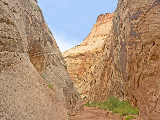
Narrows
This short hike down a deep, scenic canyon features rock art, historic inscriptions, a narrows and large potholes (water tanks) along with some historic relics from when the canon was part of the main route through Capitol Reef.
- Distance: 1.9 - 4.6 miles (RT)
- Elevation: 5,420-ft. at Trailhead
Maximum elevation - 5,250-ft. - Elevation Gain: -170-ft.
- Difficulty: easy
- Basecamp: Capitol Reef
- Region: South Central Utah
Trail Description - Capitol Gorge
Capitol Gorge, a natural passage through Waterpocket Fold, has been used by Native Americans and settlers as a main route through Capitol Reef. In 1884 the gorge was cleared by Mormon Pioneers as part of the Blue Dugway, which permitted wagon transport through the area. The route was used by wagons and later automobiles until 1964 when Highway 24 was built.
The trailhead for the Capitol Gorge hike is located at the eastern end of the parking area (see driving directions below). Here you will find a covered picnic area. Walk through the picnic area to find the beginning of the trail.
The first 0.3 miles of the trail is along a bench on the left (north) side of the canyon. As you walk along the bench watch for rock art along the canyon walls including hand prints and a vandalized petroglyph panel with several faded human-like figures. A short distance beyond the panel, look for inscriptions high on the right (south) canyon wall left by surveyors working in the gorge in 1911.
Soon the bench ends and the path drops into the wash. As you head downstream the canyon narrows. Massive Wingate sandstone cliffs and Navajo sandstone domes towering overhead.
At 0.5 miles reach the Pioneer Register, marked by a sign. Here you will see two panels of names that are carved and painted on the rock.
As you continue down the canyon you may notice metal pipes sticking out from the canyon walls. The pipes were once used to run telephone lines through the canyon.
Reach the junction with the trail to the tanks at 0.9 miles. A rugged 0.2 mile trail, marked with rock cairns, climbs steeply to a slickrock bench and then levels out as it turns left (west) and ends at an area with large potholes (tanks) that holds water after it rains. A small bridge is located nearby. The area is quite scenic with fine views of the Navajo sandstone domes rising to the northwest. The tanks are the turnaround point for most people, resulting in a 1.9 mile round-trip hike.
Beyond the spur trail to the tanks the path continues down Capitol Gorge to the park boundary. It’s a nice hike if you would like a longer walk. As you head downstream watch for more inscriptions along the canyon’s walls.
Reach a bypass trail at 1.8 miles where the trail now follows an old road bed along a bench above the right (south) side of the canyon. This bypass is necessary to circumvent obstacles in the wash. As second bypass is encountered at a check dam, now filled with silt and gravel. Here a bypass route heads around the left (north) side of the canyon to get around the old dam.
As you near the park boundary the walk becomes less interesting as the canyon widens and the walls become lower. Reach the end of the trail and the park boundary at 2.3 miles. Here you will see the rusted body of an old car, partially buried in the wash.
At the boundary simply turn around and retrace your steps back to the trailhead for a 4.6 miles RT hike.
Elevation Profile
Driving Directions
Capitol Reef Visitor Center: Turn right out of the Visitor Center on Campground Road, which turns into Scenic Drive. Travel 7.8 miles south to the end of the paved portion of Scenic Drive to an intersection. Bear right on the Capitol Gorge Road. Drive 2.3 miles to the end of the graded dirt road and the trailhead for Capitol Gorge and the Golden Throne. The trail is found beyond the eastern end of the parking after, on the far side of a covered picnic area.
Trail Resources
- Trail Photo Gallery
- Trail Maps
- Basecamp(s) Information: Capitol Reef
- Region Information: South Central Utah
- Other Hiking Regions in: Utah