Tuff Canayon
This short hike visits two overlooks and then descends into Tuff Canyon, with walls composed of volcanic ash welded into rock. The walk up the canyon offers evidence of Big Bend’s volcanic past along with nice views of canyon and the surrounding area.
- Distance: 1.1 miles (RT)
- Elevation: 2,390-ft. at Trailhead
Maximum elevation - 2,275-ft. - Elevation Gain: -115-ft.
- Difficulty: easy
- Basecamp: Big Bend
- Region: Texas Parks
Trail Description - Tuff Canyon
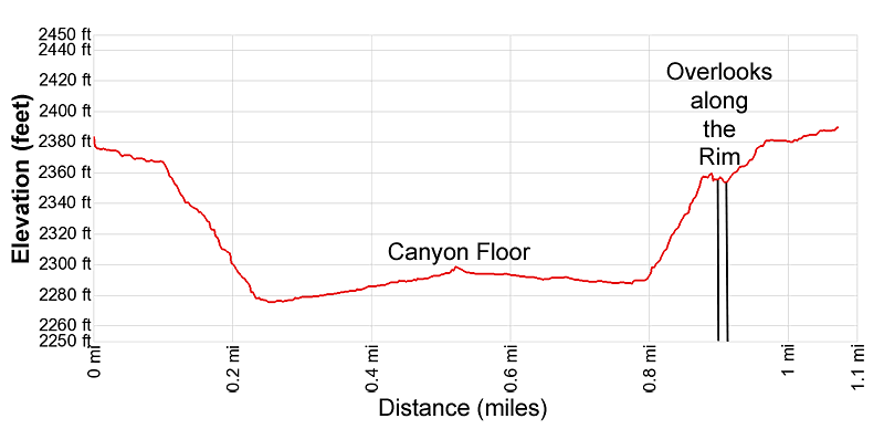
There are three overlooks for Tuff Canyon and a short trail that leads down into the canyon. This description visits two of the overlooks and explores the canyon floor.
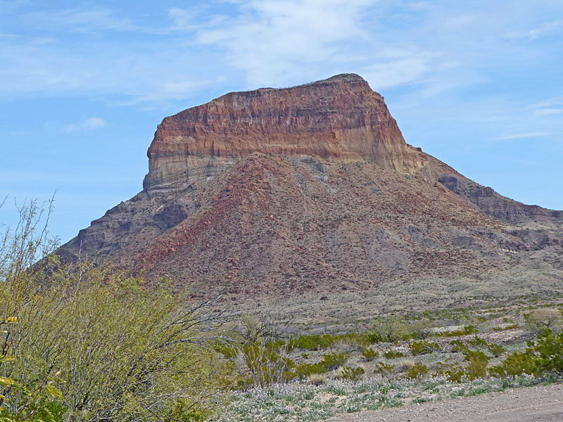
The Tuff Canyon trail starts at the southwest end of the Tuff Canyon parking area (see driving directions below). The path heads southwest, briefly paralleling the highway, accompanied by fine views of Cerro Castellan rising to the west. Soon the trail curves to the right (west) and descends gentle through the desert passing two junction leading to overlooks along the canyon’s south rim. We will leave the overlooks to the end of the hike.
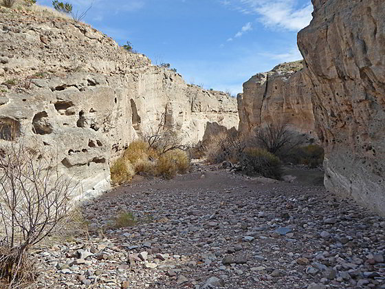
At 0.2 miles the trail curves sharply to the right (northeast) and drops down to the floor of Tuff Canyon. Here the trail heads up the wash on gentle grades between low canyon walls composed of tuff, a type of pyroclassic volcanic material that is explosively ejected by volcanic activity.
Tuff is predominately composed of volcanic ash (the light material) mixed with some darker rocks and boulders. The hot ash particles fuses together, hardening into rock embedded with the darker materials that you see along the canyon walls.
The ash in the tuff walls is more easily eroded than other types of rock, such as solidified molten lava which you will see further up the canyon. As the tuff erodes the other darker materials fall out, leaving holes and indentations along the canyon’s walls.
Initially the walk up the wash, composed of rocks, boulders and sand, is easy. But it gets progressively rockier as you near the end of the hike.
At 0.5 miles we reach a sign marking the end of the hike. Ahead is a dark ledge composed of the harder solidified lava, embedded with rocks and boulders. Since this layer is harder and does not erode as quickly the level of the wash is higher beyond this point. Parts of the canyon walls are also composed of the darker, harder layer.
After exploring the area, turn around and retrace your steps to the junction leading to the overlooks at 0.8 miles. Follow the path as it parallels the rim and visits two overlooks providing bird’s-eye-views into the canyon. At the last overlook the path turns south and leads back to the parking area for a 1.1 mile hike.
To see the canyon from a slightly different perspective walk through the parking area to the northeast end of the lot. Here a trail heads north to an overlook above the turnaround point for the trail along the canyon bottom.
Elevation Profile
Driving Directions
From the Big Bend National Park Headquarters at Panther Junction: From Panther Junction, at the intersection of the Persimmon Gap Road and the West Entrance Road, head west on the West Entrance (Gano Springs) road toward Basin Junction. Follow the road for 12.7 miles and then turn left on the Ross Maxwell Scenic Drive. Continue on the Ross Maxwell Scenic Drive for 19.9 miles to the Tuff Canyon Overlook and Trailhead, located on the west side of the road.
From the Chisos Mountain Lodge Area: Head northeast on Chisos Basin Road for 6.4 miles and then turn left onto the West Entrance Road. Follow the West Entrance Road for 9.5 miles and the turn left onto the Ross Maxwell Scenic Drive. Drive 19.9 miles on the Ross Maxwell road to the Tuff Canyon Overlook and Trailhead, located on the west side of the road.
Trail Resources
- Trail Photo Gallery
- Trail Maps
- Basecamp(s) Information: Big Bend
- Region Information: Texas Parks
- Other Hiking Regions in: Texas