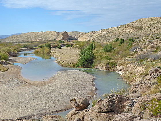
Beautiful views west along the Rio Grande
This beautiful trail travels through the Chihuahuan desert and along the rim of Hot Springs Canyon with terrific views of the Rio Grande, the Sierra Del Carmen Range and the Chisos Mountains. A visit to the Hot Springs Historic District adds interest to the hike.
- Distance: 1.1 - 6.2 miles (RT)
- Elevation: 1,836-ft. at Trailhead
Maximum elevation - 2,190-ft. - Elevation Gain: 354-ft.
- Difficulty: moderate
- Basecamp: Big Bend
- Region: Texas Parks
Trail Description - Hot Springs Canyon
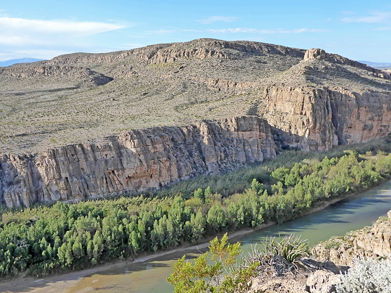
This hike passes through a beautiful section of the Chihuahuan Desert, with an interesting variety of cacti and other plants, accompanied by far reaching views of the Rio Grande, the Chisos Mountains and the Sierra Del Carmen Range. The trail is totally exposed to the sun and is very hot due to the area’s light colored stone and soil reflecting the sun’s rays.
On a hot day there are two ways to shorten the hike. The first option is to drive to the Hot Springs Historic Area (see driving directions below, a walk the 1.1 miles loop starting at the General Store/ Post Office. (Reverse the route below.) The second option is to simply walk to from the Daniel’s Ranch to the Rio Grande Overlook for at 0.6 mile hike. This option can be expanded for more fine views by walking to the high points at 0.7 and 0.9 miles. (See the description below for more information.)
From the Daniels Ranch Parking area near Rio Grande Village (see driving directions below), walk to the intersection in front of the ranch house. Here a sign points northeast toward the Hot Springs Canyon Trail. Walk northeast along the tree lined road for 300-ft. to the signed trailhead on the left side of the road.
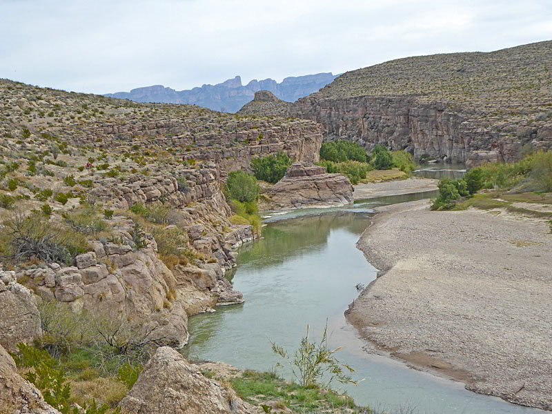
The trail immediately starts ascending the east facing slopes of a limestone cliff on moderate to moderately-steep grades. A few switchbacks facilitate the ascent. To the east are great views of the Sierra Del Carmen Mountains. At 0.3 miles the trail reaches the plateau atop the cliffs and then a junction with a spur trail branching left toward the Rio Grande Overlook. Take a short side trip to the overlook to enjoy fine views of the Rio Grande, the Sierra Del Carmen Mountains and Hot Springs Canyon.
Return to the junction and turn left (north) on the continuation of the trail. The path now ascends north/northwest away from the canyon rim on a detour that circumvents a side canyon. Follow the trail as it ascends across the plateau through a nice collection of cacti and plants. At 0.7 miles we reach the first of two high points along the trail. Here vistas extend northwest to the Chisos Mountains.
The undulating trail crosses a few drainages and curves to the left (west) on its way to the second high point at 0.9 miles. Beyond the high point the trail descends on moderate grades, crossing a drainage at 1.25 miles. This section of the trail is accompanied by more great views of the Chisos Mountains.
As the path climbs out of the drainage is swings to the left (south), traveling along rolling terrain above the west rim of the side canyon. The side canyon grows deeper as the trail heads back toward the Rio Grande.
Reach the rim of the Rio Grande at 1.7 miles. To the east are distant views of the Sierra Del Carmen Range. To the west the Rio Grande flows through an area of low hills and domes set amid the desert.
The trail now descends along the rim through the beautiful Chihuahuan desert sprinkled wide a nice variety of cacti and wildflowers, in season. As the path approaches the river is curves right and descends to the floor of a tributary canyon along the Rio Grande at 2.1 miles. After crossing the typically dry wash of the side canyon the trail soon emerges along the north bank of the Rio Grande.
Dense foliage along the river forces the trail to ascend along the slopes above the river before dropping down to the floor of a second tributary canyon. After crossing the second side canyon the trail ascends to a trail junction above the low cliff rimming the river at 2.5 miles. The junction marks the beginning of a loop trail that lead to the Hot Springs Historic area. The trail to the left travels along the river while the trail to the right ascends along the hills above the river.
My preference is to stay high at this point. Bear right and ascends on moderate grades along the hills above the river, crossing above the head of two shallow side canyons. At 2.7 miles the trail starts descending, along the way circumventing two more side canyon before dropping down to the General Store/Post Office and a large palm tree at the Hot Springs Historic Area at 3.1 miles. This segment of the trail feature more fine views of the Sierra Del Carmen Mountains to the east and the Rio Grande.
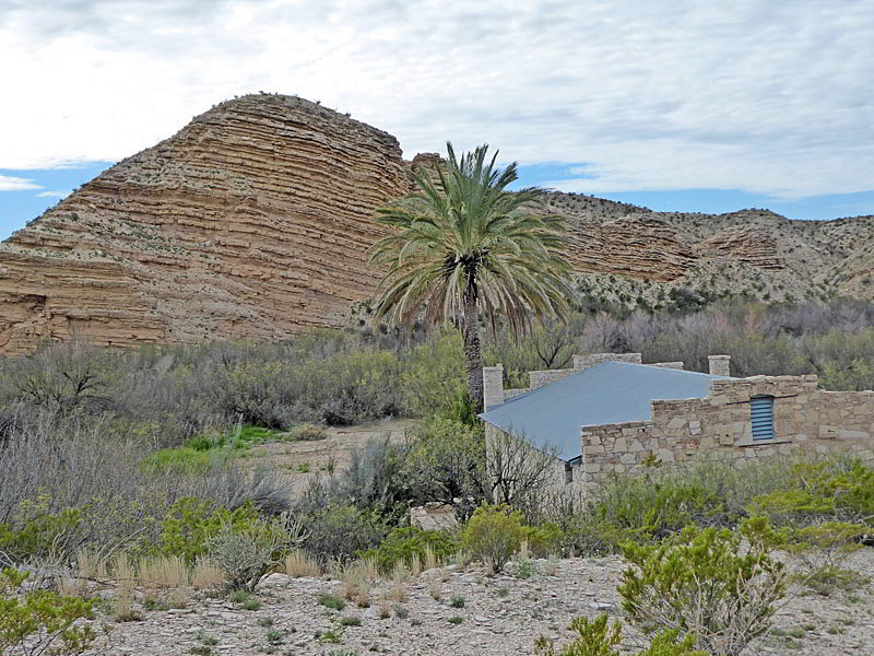
The Hot Spring Historic area, containing the remains of a health resort, homestead and hot springs, is set against the backdrop of a photogenic layered hill along the north side of a tributary canyon of the Rio Grande. A parking area adjacent to the resort is accessed by a dirt spur road off the Rio Grande Village Road.
Take some time to explore the Historic Area. When you are ready to continue the hike return to the General Store/ Post Office and follow the loop trail as it turns to the east on a broad track that passes the Resort’s motel rooms. Rock art, including pictographs and petroglyphs, adorn the limestone cliffs just beyond the motel.
Past the village the trail travels on a sandy track beneath rugged cliffs along the Rio Grande. Unfortunately thick vegetation between the track and the river initially block the river views. The cliffs harbor wildflowers, in season, along with bird’s nests.
At 3.4 miles reach an opening in the vegetation. Here, along the banks of the Rio Grande, is the foundation of the resort’s old bathhouse and the dammed hot springs (105-degrees). The hot springs are still a popular spot to take a dip.
Past the bathhouse the views open along the river and the trail soon reaches the end of the loop at 3.6 miles. Retrace your steps along the trail, returning to the Daniel’s Ranch parking area at 6.2 miles.
Note: If you decided to walk the loop from the Hot Springs Historic area the distance is 1.1 miles with a 190-ft. elevation gain.
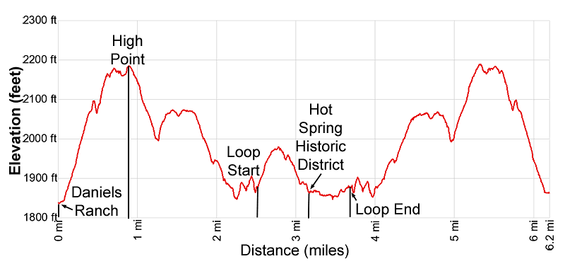
Elevation Profile
Driving Directions
To the Daniels Ranch from the Big Bend National Park Headquarters at Panther Junction: From Panther Junction, at the intersection of the Persimmon Gap Road and the Rio Grande Village Road, head southeast on the Rio Grande Village Road toward Rio Grande Village. Follow the road for 20.3 miles and then turn right on the Daniels Ranch Road. Follow the Daniels Road for 0.7 miles to the Daniel’s Ranch Parking area on the left (south) side of the road. Park here. There is an intersection in front of the ranch house with a sign pointing northeast to the Hot Spring Canyon Trail. Walk northeast up the road for 300 feet to the signed trailhead on the left side of the road.
To the Daniels Ranch from the Chisos Mountain Lodge Area: Head northeast on Chisos Basin Road for 6.4 miles and then turn right onto the West Entrance Road. Follow the West Entrance Road for 3.2 miles to the “T” intersection at Panther Gap. Continue straight ahead on the Rio Grande Village Road toward Rio Grande Village. Follow the road for 20.3 miles and then turn right on the Daniels Ranch Road. Follow the Daniels Road for 0.7 miles to the Daniel’s Ranch Parking area on the left (south) side of the road. Park here. There is an intersection in front of the ranch house with a sign pointing northeast to the Hot Spring Canyon Trail. Walk northeast up the road for 300 feet to the signed trailhead on the left side of the road.
To the Hot Spring Historic District from Big Bend National Park Headquarters at Panther Junction: From Panther Junction, at the intersection of the Persimmon Gap Road and the Rio Grande Village Road, head southeast on the Rio Grande Village Road toward Rio Grande Village. Follow the road for 16.8 miles and then turn right on to Hot Springs Road, a dirt road that descends on switchbacks to a parking area in the Hot Springs Historic Area at 1.6 miles.
To the Hot Spring Historic District from the Chisos Mountain Lodge Area: Head northeast on Chisos Basin Road for 6.4 miles and then turn right onto the West Entrance Road. Follow the West Entrance Road for 3.2 miles to the “T” intersection at Panther Gap. Continue straight ahead on the Rio Grande Village Road toward Rio Grande Village. Follow the road for 16.8 miles and then turn right on to Hot Springs Road, a dirt road that descends on switchbacks to a parking area in the Hot Springs Historic Area at 1.6 miles.
Trail Resources
- Trail Photo Gallery
- Trail Maps
- Basecamp(s) Information: Big Bend
- Region Information: Texas Parks
- Other Hiking Regions in: Texas