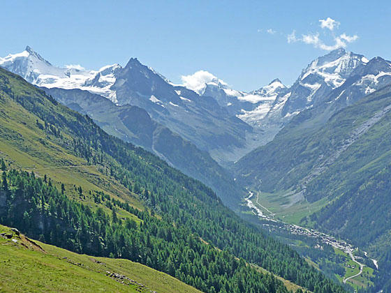
Looking toward the Zinal Valley
Highlights of this scenic walk between St. Luc and Zinal include magnificent views of the high peaks and glaciers gracing the skyline at the head of the Zinal Valley and panoramic views of the rugged summits towering above the Rhone and Anniviers Valleys.
See Trail Detail/Full Description
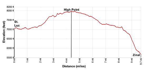
- Distance: 9.7 miles (one way) to Zinal
- Elevation: 7,145-ft. at Trailhead
7,975-ft. at Zinal - Elevation Gain: 830-ft. to Zinal
- Difficulty: moderate-strenuous
- More Hikes in:
Zinal / The Valais
Why Hike St. Luc to Zinal
This high traverse above the Anniviers Valley is one of my favorite hikes in the Zinal area. The trail features almost nonstop, breathtaking views of the massive glacier-clad peaks rimming the cirque at the head of the Zinal Valley and the summits towering above the Anniviers and Rhone valleys.
The day starts with a ride up the St. Luc funicular to Tignousa (7,145-ft.) where we get an introduction to the coming attractions. Just outside the upper funicular station views extend south to the Matterhorn rising above the high peaks at the head of the Zinal Valley. To the west a rugged ridge rims the Anniviers valley with vistas stretching to the summits rising above Grimentz to the southwest.
An easy walk, traveling through meadows and trees along the Path of the Planets, soon leads to a trail ascending to the Hotel Weisshorn. This Victorian gem, set atop a grassy knoll, features wide-ranging views of the high peaks towering above the Rhone and Anniviers valleys.
From the hotel the path ascends along the east side of the Anniviers Valley. As you climb views slowly unfold to the magnificent cirque of jagged peaks, clad in glistening glaciers, ringing the head of the Zinal Valley. The distinctively-shaped summit of the Matterhorn rises beyond the cirque. For the remainder of the hike these views evolve and improve as we approach the Zinal Valley.
Beyond the trail's high point, the path gradually descends, contouring around side valleys as it heads south toward Zinal. Along the way the trail traverses meadows sprinkled with wildflowers, passes hillsides cloaked in heather and travels by small Alps (farms).
With 1.5 miles left to go the trail starts the steep descent to Zinal, dropping through trees and intermittent meadows providing our last views of the high peaks. The trail ends above the east side of Zinal, where signs lead down through the village to the shops, hotels and the bus station.
This trail can be hiked in either direction. I strongly advise walking from St. Luc to Zinal so that the amazing views are right in front of you. Some parties choose the hike the trail starting in Zinal and then spending a night at the Hotel Weisshorn before crossing Meidpass to Gruben. If you do walk in reverse, be sure to stop frequently and turn around so you don't miss the great views.
Whatever way you walk pick a day full of promise and get an early start so you can spend a leisurely day enjoying the amazing vistas on this great hike.
Elevation Profile
| Support our Site |
Trail Resources
Trail Detail/Full Description / Trail Photo Gallery / Trail Map
Basecamp(s) Information:
Zinal
Region Information:
The Valais
Other Hiking Regions in:
Switzerland