Grosse Scheidegg to First 
Distance: 3.5 miles
Bernese Oberland, near Grindelwald in The Bernese Oberland
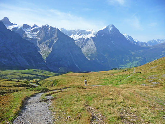
Impressive peaks rising to the south of Grindelwald
The trail between Grosse Scheidegg and First follows an undulated path through bucolic meadows with evolving, panoramic views of the massive peaks, adorn with glistening glaciers, towering above the Grindelwald Valley. Along the way waterfalls, wildflowers and small alps add interest to the hike.
- Distance: 3.5 miles (One Way)
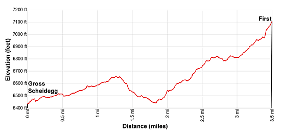
- Elevation: 6,452-ft. at Trailhead
Maximum elevation - 7,110-ft. - Elevation Gain: 658-ft.
- Difficulty: moderate
- Basecamp: Grindelwald
- Region: The Bernese Oberland
Trail Description - Grosse Scheidegg to First
Take the bus to Grosse Scheidegg, the saddle on the ridge separating Grindelwald from the Rosenlaui Valley to the northeast. (See trailhead directions below.) Signs at the pass direct walkers to the broad dirt track heading northwest toward Schreckfeld, First and the Faulhorn on the Hohenweg 2400.
Follow the path as it ascends on easy grades along the top of the ridge accompanied by ever improving views of the high peaks, including the Mattenberg, the Monch and the Eiger, rising to the southwest. The Wetterhorn towers above the saddle while below the village of Grindelwald lies cradled in an emerald green basin, bound to the west by the Mannlichen ridge.
At 0.8 miles reach a 3-way junction where signs point right (northeast) to Schwarzwaldalp and Kaltenbrunnen (Chaltenbrunnen). The continuation of the road drops left to Schreckfeld, First and the Faulhorn. We leave the road and continue on the Hohenweg 2400 trail, which ascends above the right side of the road, toward First and the Faulhorn.
The trail curves to the left, traveling through pretty meadows along the base of the Schwarzhorn. At 1.2 miles the path descends on easy grades and soon crosses a wood bridge over a stream cascading down a rocky cleft carved into the hillside.
Reach a junction at 1.8 with a trail branch right (northwest) toward the Schwarzhorn. We continue straight ahead on the Hohenweg 2400 toward First. Before long the trail drops down to and joins a broad dirt track. Views open to the Schreckhorn and Klein Schreckhorn, rising along the ridge above the Mattenberg. To the north are interesting rock formations along the cliffs above the trail.
The track now starts ascending on moderate grades, crossing another stream at 2.1 miles. The grade eases at 2.7 miles where a second trail branches right (north) towards the Schwarzhorn. Here we get our first views of the Fiescherhorn massif towering above the Fiescher Glacier nestled in a bowl behind the Eiger.
Follow the trail as it curves to the left (southwest) and soon joins with a gravel road coming up from Schreckfeld. Beyond the junction the ascent resumes on moderate grades. Watch for a trail branching left from the road at 3.3 miles. Follow this trail, which cuts-off a long switchback on the road, as it climbs steeply to First (7,110-ft.) at 3.5 miles.
First is the highest station for the Firstbahn Gondola, which starts in Grindelwald. The station is situated atop a minor summit with stunning views of the Wetterhorn, Schreckhorn and Eiger. Glaciers spill down the flanks of the massifs into the deep incised gorges between the peaks. Views extend southwest to Klein Scheidegg and the Jungfrau.
First features a popular restaurant with a sun terrace and a “Cliff Walk”, a cantilevered metal walkway bolted to the sheer west face of the First summit that leads to a 150-ft. long viewing platform with panoramic views of the 4,000-meter peaks towering above the south side of the valley. The walkway connects with the restaurant’s sun terrace where signs identify the peaks.
When you are done enjoying the views take the First gondola back to Grindelwald. Alternatively, extend the hike with a visit to the Bachsee. The visit to this beautiful lake adds 3.8 miles (round-trip) to the hike with an additional elevation gain of 360-ft. For more information see the First to the Bachsee trail description.
Elevation Profile
Driving Directions
From the Grindelwald Bahnhof (Train Station) to Grosse Scheidegg: Walk east from the train station a short distance along Dorfstasse (the main street in Grindelwald) to the main bus stop (Buswenderplatz) on the south side of the street. Purchase bus tickets at the small ticket booth for Grosse Scheidegg. Take the bus bound for Grosse Scheidegg or Schwarzwaldalp and get off at Grosse Scheidegg. The trip takes 36 minutes.
If you are staying in town, you can also catch the bus at one of several bus stops along the main street. Each stop is named with a sign. Logon to the SBB website or download the app to see the departure times from the stop nearest your accommodations.
From the First to Grindelwald Bahnhof (Train Station): Take the gondola from First to Grindelwald. When you exit the gondola walk down to Grindelwald’s main street (Dorfstrasse) and turn right (west). Walk along the main street for 0.4 miles to the Grindelwald Bahnhof (train station).
Note: The First gondola it a multi-stage lift that goes through intermediate stations. At all stations remain seated. The doors will open allowing passengers who wish to get off at the intermediate stations to leave the gondola and then close, continuing the journey to Grindelwald.
Trail Resources
- Trail Photo Gallery
- Trail Maps
- Basecamp(s) Information: Grindelwald
- Region Information: The Bernese Oberland
- Other Hiking Regions in: Switzerland