Spring Creek Pass East to Snow Mesa 
Distance: 6.4 - 10.0 miles (round trip)
Rio Grande National Forest, near Lake City in Southwest Colorado
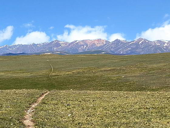
Beautiful views of the San Juans from Snow Mesa
Hikers ascending from Spring Creek Pass to the beautiful, tundra-clad plateau of Snow Mesa are rewarded with glorious views of the San Juan Mountains to the west/southwest of the Lake City area. Extend the hike by climbing Baldy Cinco or walking to the ponds at the east end of the mesa.
See Trail Detail/Full Description
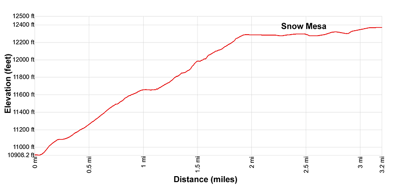
- Distance: 6.4 miles (round trip) to Spring Creek Pass East
- Elevation: 10,898-ft. at Trailhead
12,380-ft. at Spring Creek Pass East - Elevation Gain: 1,482-ft. to Spring Creek Pass East
- Difficulty: moderate-strenuous
- More Hikes in:
Lake City / Southwest Colorado
Why Hike Spring Creek Pass East to Snow Mesa
Views, views and more views are the hallmarks of this hike climbing to Snow Mesa, the largest expanse of tundra in the lower 48 states. The scenic wonderland is easily visited by driving south from Lake City along Highway 149 to Spring Creek Pass. From the highway the trail climbs steadily through forest and then rocky meadows and sections of talus to the western rim of Snow Mesa in 1.9 miles.
From Snow Mesa views of the San Juan Range extend from the Rio Grande Pyramid in the Weminuche Wilderness to the southwest to Uncompahgre, Wetterhorn and Matterhorn Peaks in the Uncompahgre Wilderness to the northeast. A near level expanse of tundra stretches as far as the eye can see to the east while Baldy Cinco, Baldy No Es Cinco and three nearby summits rise to the northeast.
On a beautiful day the easy walk across the tundra is a sheer joy, with frequent stops to take in the views. For a shorter hike ascend gently cross the tundra to a high point just to the south of Baldy Cinco. Extend the hike by continuing to the small ponds near the eastern edge of the mesa or climb Badly Cinco and Baldy No Es Cinco.
Keep an eye on the weather atop the mesa. This is not a place to be during a thunder storm. Turn around if you see the weather taking a turn for the worse.
Elevation Profile
| Buy the BookThis opinionated guide includes all the hikes in the Ouray, Telluride, Silverton and Lake City sections of the website plus info on local services and nearby attractions. |
Trail Resources
Trail Detail/Full Description / Trail Photo Gallery / Trail Map
Basecamp(s) Information:
Lake City
Region Information:
Southwest Colorado
Other Hiking Regions in:
Colorado