Mosquito Lakes 
Distance: 7.2 - 9.0 miles
Sequoia-Kings Canyon National Park, near Mineral King in California's Southwestern Sierra
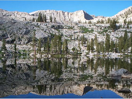
View of the second Mosquito Lake
This trail follows the path to Eagle Creek for the first 2 miles and then crosses Miner’s Ridge to the Mosquito Lake #1, a small, shallow lake surrounded by red firs. A use trail leads to Lake # 2, a beautiful alpine gem cradled in a granite basin. Use trails and cross-country routes climb the rocky basin to the other three lakes. The last two lakes are the most scenic, set amid a rugged basin and surrounded by steep granite ridges anchored to the southwest by Hengst Peak (11,146-ft.).
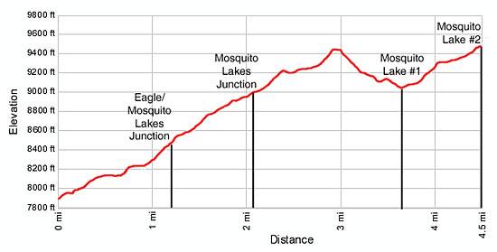
- Distance: 7.2 miles (round trip) to First Lake
9.0 miles (round trip) to Second Lake - Elevation: 7,830-ft. at Trailhead
9,450-ft. at First Lake
9,580-ft. at Second Lake - Elevation Gain: 1,620-ft. to First Lake
2,145-ft. to Second Lake - Difficulty: moderate-strenuous
- Basecamp: Mineral King
- Region: California's Southwestern Sierra
Trail Description - Mosquito Lakes
The Mosquito Lakes / Eagle Lake trail starts at the south end of the Eagle / Mosquito parking area. Follow the trail as it heads south, ascending along the west side of the beautiful East Fork Kaweah River valley on an easy grade through scrub covered hillsides, sprinkled with scattered fir and junipers. A profusion of willows grow along the river banks and in the marshy areas of the meadows lining the valley floor. Vandever Mountain (11,947-ft.) and Farewell Gap, the saddle to the east of the peak, frame the head of the valley.
Cross a small wood bridge over Spring Creek at 0.3 miles. Tufa Falls, a small waterfall on the creek, is hidden by the thick foliage above the trail. Water flowing in the creek is believed to travel underground along fractured marble bands that surface on the hillside high above the trail.
Beyond the creek the trail continues it steady ascent, passing through scatter stands of firs and junipers. Across the valley Crystal Creek tumbles down a rocky cleft carved in the steep hillside.
Eagle Creek cascades over the trail at 0.9 miles and is easily crossed on rocks. Past the creek the trail steepens and reaches a junction at 1.2 miles. The trail branching to the left leads to White Chief. Turn right on the Eagle / Mosquito Lakes trail and follow the moderately steep trail as it climbs switchbacks traversing the forested hillside toward the Eagle Creek basin. Openings in the trees offer views of Crystal Creek and the peaks rising above the northeastern side of the valley.
The grade abates as the trail skirts the edge of a pretty meadow and turns southwest in to the forested lower basin. At 1.8 miles reach Eagle Creek where it drops into and is swallowed by a large sink hole.
Past the sink hole the trail crosses to west side of the basin and continues its ascent on easy grades through forest and small meadows. Reach the junction with the trail to Mosquito Lakes trail at 2.1 mile. The trail to the left heads to Eagle Lake. Turn right and follow the trail as it climbs north/northwest through open meadows and then trees to the top of Miner’s Ridge, gaining 400-ft. in 0.7 miles.
From the top of the forested ridge the trail curves southwest, dropping 370-ft. through thick forest to the northern shore of Mosquito Lake #1 (9,055-ft.), 3.6 miles from the trailhead. The small, shallow lake is surrounded by red fir forest. This is the end of the maintained trail.
To reach the second lake, cross the outlet stream and follow the use trail ascending the rocky hillside on the west side of the lake. Beyond the lake the route, marked with rock cairns and blazes, heads south through scattered trees and then climbs the steep headwall to the Mosquito Lake #2 (9,580-ft.), 4.5 miles from the trailhead. The pretty lake is cradled in a granite basin.
The second lake is the typical turnaround point for day hikers. Backpackers and day hikers with the time and energy to explore further can followed the cairned route up valley to three more lakes. The last two lakes are the most scenic, set amid a rugged basin and surrounded by steep granite ridges anchored to the southwest by Hengst Peak (11,146-ft.).
Be aware that the lakes are aptly named. Be sure to bring plenty of bug spray.
Elevation Profile
Driving Directions
From Visalia: Follow Highway 198 East for 31.5 miles to the Mineral King Road. (There is a small green sign by the road that read “Mineral King 25 miles”.) Turn right onto the Mineral King Road and follow the narrow, winding road for 23.5 miles to the Eagle/Mosquito parking lot at the end of the road.
Trail Resources
- Trail Photo Gallery
- Trail Maps
- Basecamp(s) Information: Mineral King
- Region Information: California's Southwestern Sierra
- Other Hiking Regions in: California